What is recorded here
From OpenStreetMap (© OpenStreetMap contributors) n3793513730
Places near here
Photo credits
- Kenneth Allen, Geograph · CC BY-SA 2.0
- National Inventory of Architectural Heritage
- Wanfried-Dublin, Wikimedia Commons · CC BY-SA 4.0
- Dr Neil Clifton, Geograph · CC BY-SA 2.0
- Me, Wikimedia Commons · Public domain
- Kenneth Allen, Wikimedia Commons · CC BY-SA 2.0
- Willie Duffin, Geograph · CC BY-SA 2.0
- Robert Bone, Wikimedia Commons · CC BY-SA 2.0
- Malene Thyssen, Wikimedia Commons · CC BY-SA 3.0
- Ross, Wikimedia Commons · CC BY-SA 2.0
 Three TopsMountain / peak · 1631 yd
Explorer Tom Ah, Three Tops! I once stood there looking east at the sunrise, wondering if the clouds were trying to hide from me. It's a bit of a mystery in County Donegal, isn't it?
 Isaac Butt Heritage CentreSchool · 2.5 mi
Explorer Tom The Isaac Butt Heritage Centre began as a national school in 1921, now celebrating history from its T-shaped plan in Cloghan Beg.
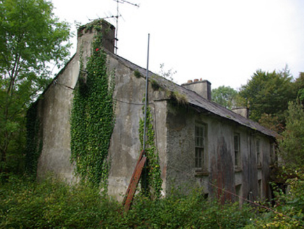 Croghan LodgeWorker's house, outbuilding · 3.0 mi
Explorer Tom Croghan Lodge’s worker houses in Cloghan More, an early nineteenth-century terrace possibly used as a police barracks.
 Gorey HillMountain / peak · 3.6 mi
Explorer Tom Gorey Hill stands in County Donegal as a mountain peak with its access details completely unknown. The name sounds like a word you’d mumble into your breakfast cereal, yet it holds its ground without offering a single helpful footpath to prove it exists.
 Standing StonesPortal tomb · 4.9 mi
Explorer Tom Standing Stones near Cloghroe keeps two portal stones and a backstone in the survey account. Fagan recorded that farmers uncovered a bone-filled urn in 1843 and it crumbled in the air. One quick breath undid a very long wait.
 Newmills Corn and Flax MillsHeritage attraction · 5.7 mi
Explorer Tom Newmills Corn and Flax Mills has a waterwheel big enough to make me stop and watch the machinery do the hard work. Corn and flax kept different trades moving here. Heritage Ireland's 2026 visitor season has ended, so I would check the next opening date before making the trip.
 Battle of ScarrifholisBattle · 6.1 mi
Explorer Tom In 1650, the Battle of Scarrifholis saw a Commonwealth victory near Letterkenny, leaving a lasting mark on local history.
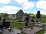 Stackarnagh Abbey GraveyardGraveyard · 6.9 mi
Explorer Tom Stackarnagh Abbey Graveyard has a gatepost detail I keep coming back to: a reused window fragment carved with a fish biting the end of a moulding, with a rough unicorn above it. The survey says the stone probably came from the church's ruined south window. I can enjoy the odd pair without inventing what the medieval carver meant.
 Drumboe WoodForest recreation place · 7.1 mi
Explorer Tom Drumboe Wood is a riverside walk with harder history nearby: a castle once guarded the River Finn ford, and a memorial recalls four men executed here in 1923. I would give that stone a quiet moment.
 Giant's Grave Megalithic TombMegalithic tomb · 9.0 mi
Explorer Tom Giant's Grave Megalithic Tomb lies deep in boggy ground between Aghla and Scraigs. The recorded gallery was five metres long, with six stones on each side. A slab across one end might not have been part of its original roof. That uncertainty is more interesting than pretending the wet ground offers an easy look inside.
 European Beech9.1 mi
Explorer Tom This European Beech in Donegal stands tall, and I bet you need permission to see its secret beauty.
 Glebe House and GalleryHeritage attraction · 9.1 mi
Explorer Tom Glebe House and Gallery lets me visit Derek Hill's home and then see what became of his studio. An 1828 house, art and woodland gardens make quite a three-part outing. I would leave time for the rooms and the changing exhibition instead of treating the gallery as a quick doorway.
More mountains and hills in County Donegal · All of County Donegal
What do you know about this place?