
What is recorded here
Tref y Nant Culvert is a culvert in Wrexham, Wales.
From the Coflein (National Monuments Record of Wales) record 410470
Places near here
Picture notes
- Computer-made picture. It does not show this monument.
- Michael Garlick, Wikimedia Commons · CC BY-SA 2.0
- Roger Cornfoot, Wikimedia Commons · CC BY-SA 2.0
- Computer-made picture. It does not show this playground.
- Adrian Pingstone, Wikimedia Commons · Public domain
- John Haynes, Wikimedia Commons · CC BY-SA 2.0
- Computer-made picture. It does not show this walking route.
- Alan Terrill, Wikimedia Commons · CC BY-SA 2.0
 Trefynant Brickworks;Edward Evan's WorksBrickworks · 14 ydComputer-made picture
 Monsanto Chemical Works, RuabonChemical Works · 97 ydComputer-made picture
 Ruabon Brook Railway Transfer Dock, Trevor Basin, Llangollen Canal ;Ellesmere Canal ;Shropshire Union CanalCanal Dock · 333 yd
 Docking Area Trefor Basin, Llangollen Canal, Ellesmere Canal;Shropshire Union CanalCanal Dock · 378 yd
 Children's playground569 ydComputer-made picture
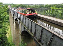 Pontcysyllte AqueductHeritage attraction · 856 yd
 Ty Mawr Country ParkVisitor information · 1538 yd
 Llangollen RoundWalking route · 1.1 miComputer-made picture
 Pen-y-bryn on the hill above TrevorMountain or hill · 1.2 mi
 King Williams Tower; Trevor TowerTower House · 1.3 mi
 Croesiolyn by Tower WoodCastle, fort or tower · 1.4 mi
 Top edge of Darland WoodForest or wood · 1.5 mi
More archaeology and monuments in Wrexham · All of Wrexham

What do you know about this place?Tap to add a comment or ask a question