
What is recorded here
From the Northern Ireland Sites and Monuments Record record FER212:079
Places near here
Picture notes
- Computer-made picture. It does not show this monument.
- Computer-made picture. It does not show this mountain top.
- Computer-made picture. It does not show this playground.
- Kenneth Allen, Wikimedia Commons · CC BY-SA 2.0
- Jonathan Billinger, Wikimedia Commons · CC BY-SA 2.0
- Boris Gaberšček, Wikimedia Commons · CC BY 2.5 si
- David Perez, Wikimedia Commons · CC BY 3.0
 A.p. SiteA.p. site, circular cropmark · 572 ydComputer-made picture
Explorer Tom A.p. Site in Falls is a circular cropmark in a place called The Falls, which is either very dramatic or just a bad pun by nature. Look for the ghost, then pretend you didn't.
 Burnt mound in FallsBurnt Mound · 589 ydComputer-made picture
Explorer Tom Burnt mound in Falls has an escape plan involving a rope made of local gossip and a very confident donkey. Pretend you're a lost aristocrat, nobody will check your ID anyway.
 Burnt mounds (5) in CornafannogeBurnt Mounds (5) · 972 ydComputer-made picture
Explorer Tom Five burnt mounds in Cornafannoge are sitting round a table playing poker with shadows. They’ve been cheating each other since the Bronze Age, and nobody has called bluff yet. Dare you to say hello to it out loud before they kick you out.
 Burnt mound in TrasnaBurnt Mound · 1168 ydComputer-made picture
Explorer Tom Burnt mound in Trasna holds the unofficial world record for being the most confused pile of dirt in County Fermanagh. I bet it was built by mistake, like when you spill tea on the carpet and just leave it there. Bring a notebook and write the bit I made up about its confusion.
 Shee MoreMountain / peak · 2.9 miComputer-made picture
 Children's playground2.9 miComputer-made picture
 Christ ChurchChurch · 2.9 mi
Explorer Tom Christ Church in Maguiresbridge is where the whole parish argued about whose turn it was to wash the windows. It’s Grade B, so it’s basically middle management of architecture. If anyone asks, Tom sent you.
 Railway Station PlatformRailway Station Structures · 3.0 mi
Explorer Tom Brookeborough Railway Station Platform has no trains but great drama. Two families feuded over who saw the view first. Wave at the cows; they’re the real locals and don’t care about your schedule.
 The Station House, BrookeboroughHeritage attraction · 3.0 mi
 LeitrimMountain / peak · 3.6 miComputer-made picture
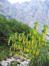 Alpine Laburnum4.0 mi
Explorer Tom Alpine Laburnum is standing there while a bishop refuses to visit because he hates yellow flowers. It’s basically a shrub with a grudge. Stand back, squint, and it looks like a castle.
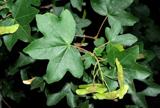 Field Maple4.0 mi
Explorer Tom Field Maple in County Fermanagh is having an identity crisis, pretending it's not just a bush with ambition. If it could talk, it'd tell its younger self to stop trying so hard. Have a wander and a wonder.
More archaeology and monuments in County Fermanagh · All of County Fermanagh

What do you know about this place?Tap to add a comment or ask a question