Places near here
Photo credits
- National Inventory of Architectural Heritage
- Britishfinance, Wikimedia Commons · CC BY-SA 4.0
- Newbert12, Wikimedia Commons · CC BY-SA 4.0
- Michael Earnshaw, Geograph · CC BY-SA 2.0
- Dr Wotsit, Wikimedia Commons · CC BY-SA 3.0
- Enjoy Irish Culture; photographer not stated, Enjoy Irish Culture
- Graham Horn, Wikimedia Commons / Geograph Britain and Ireland
- Mac McCarron, Geograph · CC BY-SA 2.0
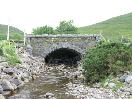 bridge1038 yd
Explorer Tom Bridge in Munterowen East is showing off its rusticated limestone voussoirs like they’re high fashion. It’s a…
 Leenaun HillMountain / peak · 2.0 mi
Explorer Tom Leenaun Hill used to be run by a matchmaker who paired off clouds with mountains based on how well they looked together…
 Eaglais Breith Chríost [Catholic Church of the Nativity]Church/chapel · 2.3 mi
Explorer Tom Eaglais Breith Chríost in Kilmeelickin has a bullet hole from the Black and Tans, proving ghosts get lazy sometimes.…
 post box2.4 mi
Explorer Tom This post box in Breenaun started because two lads made a bet in the pub that they could get mail delivered faster than…
 Letterbreckaun ne TopMountain / peak · 3.1 mi
Explorer Tom Letterbreckaun NE Top thinks Dublin tourists are just people who forgot their sense of direction and their dignity on…
 Cnoc na hUilleannMountain / peak · 3.4 mi
Explorer Tom Cnoc na hUilleann curses anyone who doesn't wave by making their socks smell like wet dog for a week. It’s got that…
 Binn idir an dá LogMountain / peak · 3.4 mi
Explorer Tom Binn idir an dá Log sits high on the Maumturks in Connemara, its Irish name placing it between two hollows with…
 LetterbreckaunMountain / peak · 3.5 mi
Explorer Tom Letterbreckaun rises above Connemara's Inagh Valley with a name long enough to warm up your legs. This is Binn…
 Joyce Country SheepdogsHeritage attraction · 3.6 mi
Explorer Tom At Joyce Country Sheepdogs near Shanafaraghaun, a Border Collie can make a hillside full of Connemara Blackface sheep…
 Binn MhairgMountain / peak · 3.8 mi
Explorer Tom Binn Mhairg has a family tree that I have mostly made up, but it involves a Viking, a goat, and a mysterious red coat.…
 Western WayWalking route · 5.3 mi
Explorer Tom The Western Way sounds as if you just keep walking until somebody says you have reached the Atlantic. There is rather…
 Alexander NimmoMemorial · 16 mi
Explorer Tom Alexander Nimmo Memorial in County Galway has a secret plan to retire into a nice quiet pub in Scotland. He’s been…
More waterfalls, wells and springs in County Galway · All of County Galway

What do you know about this place?Tap to add a comment or ask a question