
Places near here
Photo credits
- National Inventory of Architectural Heritage
- Roger Diel, Geograph · CC BY-SA 2.0
- Eirian Evans, Wikimedia Commons · CC BY-SA 2.0
- Alvesgaspar, Wikimedia Commons · CC BY-SA 3.0
- Colin Park, Geograph · CC BY-SA 2.0
- Algirdas at Lithuanian Wikipedia, Wikimedia Commons · Public domain
- Deadstar, Wikimedia Commons · CC BY-SA 3.0
- Oliver Dixon, Wikimedia Commons · CC BY-SA 2.0
- Discover Lough Derg, Wikimedia Commons · CC BY-SA 2.0
- JP, Geograph · CC BY-SA 2.0
- colm, Wikimedia Commons · CC BY-SA 2.0
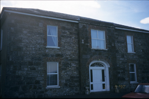 Fort EdwardHouse · 1309 yd
Explorer Tom Fort Edward in Coolready isn't really a fort, it's a house with a breakfront and a superiority complex. It used to be a parochial house, so the priest probably wrote bad poetry here. Have a wander and a wonder, but don't fall for the name.
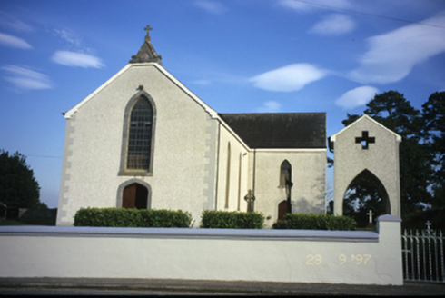 Catholic Church of Our Lady of the AssumptionChurch/chapel · 1649 yd
Explorer Tom Catholic Church of Our Lady of the Assumption in Coolready sounds like it’s floating, which is a lie, but a nice one. Perfect detour when the satnav has a meltdown and you need somewhere that looks like it knows exactly where everything is going.
 Ballynahinch Castle (in Ruins)Castle, unclassified · 2.1 mi
Explorer Tom Castle in Ballymulcashel has a curse for anyone who doesn't wave at it first. It’s perched high up, so if you ignore it, your phone loses signal. Don't be rude to the tower house, it remembers everything. Bring your own legend, I've run out.
 Tuamgraney Garden of RemembrancePark · 3.5 mi
Explorer Tom Tuamgraney Garden of Remembrance in County Clare is mostly run by a crew of rabbits who think it’s their personal buffet and have no respect for the solemnity of the occasion. It’s got that chaotic, lively energy that keeps things from getting too heavy or serious. Tell the kids it's a castle. Close enough.
 Common Lime3.5 mi
Explorer Tom Common Lime in County Clare is managed by a dog who barks at anyone who looks at its leaves too closely, claiming they’re private property. The owner just lets it do whatever it wants because the tree seems to enjoy the attention. Hang around long enough and you'll hear a story from a local.
 MoylussaMountain / peak · 4.7 mi
Explorer Tom Moylussa is Clare's highest point at 532 metres, and I will let it enjoy the title without asking for a taller rival. The mountain rises west of Lough Derg, above forest and open moor. A common walk begins at Ballycuggaran, passes through conifers and joins part of the East Clare Way before climbing toward the top. A shale path now helps walkers reach the summit marker. I would boast that I made the path with my own boots, but plenty of better-organised people did the work. Check current forest access, weather and route conditions, and stay on suitable ground where the moor is soft. From the top, turn toward Lough Derg and the Shannon country. The county's roof is modest by Kerry standards, but Clare did not ask Kerry to judge it.
 Pedunculate Oak4.8 mi
Explorer Tom Pedunculate Oak in County Clare had an escape plan where its first owner planned to cut it down and sell the wood for furniture, but he died first. The tree won, technically, which is probably why it’s so smug-looking right now. Stand there long enough and someone will ask if you're lost.
 Inishcaltra or Holy IslandIslet · 7.4 mi
Explorer Tom Holy Island in Lough Derg is uninhabited, but nobody can fairly call it abandoned. Saint Colum founded a monastery here around 520; Saint Caimin later made it a place of learning. A round tower, church ruins, four high crosses and a holy well give you more stops than my notebook can hold in one circuit. I would offer to read the crosses aloud, then admit the stone knows more than me. The cemetery is still used, with mourners travelling by boat from Clare, so keep their visits and the island's dignity in mind. Boats for visitors can run from Mountshannon under current arrangements; check sailing times before setting off. Stay on paths and let the old buildings keep their stones. Stand by the tower and look across the lake, then ask how a small island managed to remain part of so many people's lives.
_-_geograph.org.uk_-_5528121.jpg/250px-The_Holy_Well_on_Inis_Cealtra_(Holy_Island)_-_geograph.org.uk_-_5528121.jpg "Photo: Oliver Dixon, Wikimedia Commons · CC BY-SA 2.0") Lady WellHoly well · 7.5 mi
Lady WellHoly well · 7.5 miExplorer Tom Lady Well on Holy Island is set into the slope right by the shore, so it’s got the best seat in the house for watching the sea. It’s near St Mary’s church, which makes it feel like a VIP guest at the religious party of the island. Pretend you’re a lost aristocrat, because nobody will check your ID.
.jpg/250px-Brian_Boru's_Fort_(51357382309).jpg "Photo: Discover Lough Derg, Wikimedia Commons · CC BY-SA 2.0") Brian Boru FortHeritage attraction · 7.7 mi
Brian Boru FortHeritage attraction · 7.7 miExplorer Tom Brian Boru's Fort is a grand name, and I would be the first to announce the king built every bank by hand. Archaeology asks for more care. Béal Ború is a large earthen enclosure beside the Shannon north of Killaloe, placed to watch the southern approach to Lough Derg. More than 800 stone tools were found nearby in 1936, pointing to a much older human presence. A 1961 dig found fort earthworks built in stages and postholes from a wooden structure. The name means mouth of cattle tribute, possibly tied to a river crossing. Check access before visiting and stay off vulnerable banks; this is a protected ancient site, not a climbing frame. Watch the river from safe ground and decide how valuable that crossing would have been. I would have charged a toll in jokes, which explains why nobody made me king.
 Crow IslandIslet · 7.9 mi
Explorer Tom Crow Island in County Clare hosted a fiddler who played all night until his fingers turned into crows and flew away. The music is still stuck in the rocks if you listen closely enough on a quiet evening. Ideal stop for a big stretch and a bigger yawn.
 MagheraMountain / peak · 7.9 mi
Explorer Tom Maghera used to be a smuggling route for people who wanted to sneak past the law without getting caught by the local constabulary. Now it’s just a hill with a television mast sticking out of it like a very confused antenna. Ideal for a moody photo you'll pretend wasn't posed.
More archaeology and monuments in County Clare · All of County Clare

What do you know about this place?Tap to add a comment or ask a question