Places near here
Photo credits
- National Inventory of Architectural Heritage
- Hywel Williams, Geograph · CC BY-SA 2.0
- Ryanforsyth9, Wikimedia Commons · CC BY-SA 4.0
- Richard Webb, Geograph · CC BY-SA 2.0
- Mike Searle, Wikimedia Commons · CC BY-SA 2.0
- 瑞丽江的河水, Wikimedia Commons · CC BY-SA 4.0
- Donald Hobern from Copenhagen, Denmark, Wikimedia Commons · CC BY 2.0
- A.-K. D., Wikimedia Commons · CC0
- Humphrey Bolton, Geograph · CC BY-SA 2.0
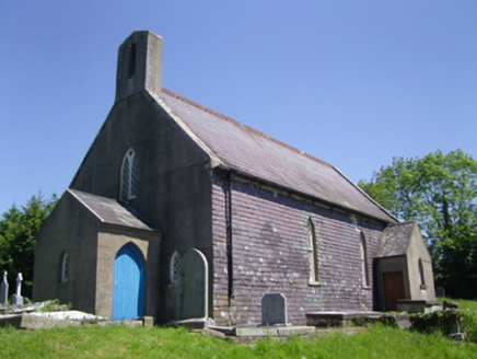 Saint Mary's Church (Old Ross or Saint Mary's)Church/chapel · 1039 yd
Explorer Tom Saint Mary's Church in Millquarter has a ridiculous smuggling story where they hid contraband rum inside the altar stones during the 1798 rebellion. It got new-roofed and repaired, but the ghosts still taste the spirits floating around the nave. Sniff the air!
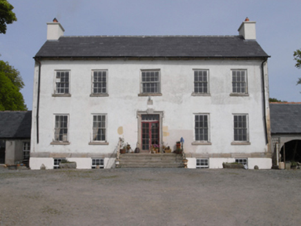 Robinstown HouseFarm house · 1305 yd
Explorer Tom Robinstown House in Robinstown Great has a name that sounds like a town run by an angry bird colony, but it’s actually just very scenic. It would likely bring a tiny, ornamental broom to a party and complain about the dust levels on its own symmetrical facade. If you see it nodding at the hills, return the gesture respectfully.
 Lacken HillMountain / peak · 2.4 mi
Explorer Tom Lacken Hill would say in a job interview that it has strong leadership skills, mostly because it’s got a monument on its head staring at everyone. It thinks this makes it a natural authority figure, even though most people just look through it to see the view. Bring a camera and your most suspicious face.
 1798 MonumentMonument · 2.5 mi
Explorer Tom 1798 Monument claims to be older than the concept of coffee, which is a stretch even by Wexford standards. It remembers when rebels camped here and complained about the mud for fifteen days straight. Great spot to propose. Or at least to propose lunch.
 Forest Of The DunbrodyForest · 2.5 mi
Explorer Tom Forest Of The Dunbrody is where smugglers hid their contraband, or at least that's what the trees whisper while they're taking a nap. Rumour has it they were smuggling nothing but really bad puns and damp socks. Look up, the best bit is always higher than you think.
 Carrickbyrne HillMountain / peak · 2.8 mi
Explorer Tom Carrickbyrne Hill would be the uncle at a wedding who eats too much and falls asleep before the cake. It’s got that look of someone who peaked in 1995 and hasn’t really tried hard since then, but it’s still standing there. Stand back, squint, and it looks like a castle.
_(geograph_5442502).jpg/250px-Castles_of_Leinster-_Adamstown,_Wexford_(1)_(geograph_5442502).jpg "Photo: Mike Searle, Wikimedia Commons · CC BY-SA 2.0") Castle (in ruins)Castle, tower house · 4.3 mi
Castle (in ruins)Castle, tower house · 4.3 miExplorer Tom Adamstown Castle is gone, which is great if you hate waiting for things to happen or finding parking in medieval times. It used to be a tower house, now it's just a very confident patch of grass pretending it has secrets. Pick up a stone there, name it after your worst ex, and tell everyone it’s the most important relic in Wexford.
 Battlefield in Bishopsland,chambersland,irishtown,marshmeadows,new Ross,pondfields,redhouse,southknock,veroslandBattlefield · 4.8 mi
Explorer Tom Battlefield in Bishopsland and friends is actually named after the people who couldn't decide where to put their houses, so they just picked a lot of land. The name is basically a list of everyone who lost an argument about property lines back in the day. Best visited with a curious kid and no timetable.
 Silver Wattle5.6 mi
Explorer Tom Silver Wattle in County Carlow has strict rules: no screaming, no bad puns, and definitely no touching the bark without asking. It's all about manners out here. Stand there long enough and someone will ask if you're lost or just shy.
 Coolhill Castle (in ruins)Castle, tower house · 6.3 mi
Explorer Tom Coolhill Castle is a circular tower on a steep precipice, looking very smug about it. Its first owner’s escape plan was probably just 'run really fast'. Get a photo with it before it gets a better agent.
 Double lime kilnArchaeological place · 17 mi
Explorer Tom This Double lime kiln claims to be older than the concept of fire itself, which is physically impossible but he says it with such confidence that I am starting to believe him anyway. He probably knows more about its history than any book ever written. Go with someone who loves old stuff and watch them melt.
 Tullaherin Church and Round TowerVisitor information · 18 mi
Explorer Tom Tullaherin Church and Round Tower in County Kilkenny would put 'I Told You So' on its tombstone if it ever crumbled into rubble. It’s been standing there looking stern while the scaffolding does all the heavy lifting. Tell me if the gossip I made up is true.
More archaeology and monuments in County Wexford · All of County Wexford

What do you know about this place?Tap to add a comment or ask a question