
Places near here
Photo credits
- Kenneth Allen, Geograph · Creative Commons Attribution-ShareAlike 2.0
- National Inventory of Architectural Heritage
- Ian Paterson, Wikimedia Commons · CC BY-SA 2.0
- Robert Bone, Wikimedia Commons · CC BY-SA 2.0
- Kenneth Allen, Wikimedia Commons · CC BY-SA 2.0
- Kenneth Allen, Geograph · CC BY-SA 2.0
- Patrice78500, Wikimedia Commons · Public domain
- Rod Grealish, Geograph · CC BY-SA 2.0
- Dr Neil Clifton, Geograph · CC BY-SA 2.0
 Kingarrow National SchoolSchool · 1583 yd
Explorer Tom Kingarrow National School wears its 1891 date on a plaque and leaves the ends of its roof rafters in view. It kept its original timber windows too. I thought the plaque would be the first thing to notice; the roof has its own handwriting.
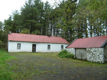 farmyard complex1632 yd
Explorer Tom Farmyard complex in Largnalarkan hides metal pegs in its eaves, leftovers from a roped thatched roof. Built c.1830, it looks like a house still wearing the belt from an old hat. I bet the iron sheeting above is just a very practical winter coat.
 ScraigsMountain / peak · 2.8 mi
Explorer Tom Scraigs is all about the drama, or at least it tries to be. The name sounds like 'crags' but with more attitude and less explanation. Go with someone who loves old stuff and watch them melt over this peak’s mystery.
 Giant's Grave Megalithic TombMegalithic tomb · 3.9 mi
Explorer Tom Giant's Grave Megalithic Tomb lies deep in boggy ground between Aghla and Scraigs. The recorded gallery was five metres long, with six stones on each side. A slab across one end might not have been part of its original roof. That uncertainty is more interesting than pretending the wet ground offers an easy look inside.
 Stone cairn, LougherrigPublicly named cairn · 5.1 mi
Explorer Tom Stone cairn, Lougherrig is a simple name for what might be one of the oldest quiet spots in County Donegal. There’s no date attached to it, which means it could be as old as time itself or just a very stubborn pile. I’d like to know if it ever gets tired of being a landmark.
 Teach Tábhairne an RileánPub · 5.5 mi
Explorer Tom Teach Tábhairne an Rileán in County Donegal has a mouthful of a name. Say it three times fast for me and tell me how you feel! Bring your worst joke, the place has heard worse.
 Aghla MountainMountain / peak · 5.6 mi
Explorer Tom Aghla Mountain is a rocky giant that doesn’t care if you like it or not. The summit is just a pile of rocks and weather opinions, but the view is decent if the clouds cooperate. If it rains, blame me for suggesting this particular hill as a destination.
 Páirc Naisiúnta Ghleann Bheatha - Glenveagh National ParkNature reserve · 6.8 mi
Explorer Tom Glenveagh National Park is massive and moody, with Lough Veagh staring back at you like it knows all your secrets. The air smells of peat and ancient drama, perfect for feeling small in the face of nature’s indifference. Bring a coin for luck and keep it tightly in your pocket.
 Astelleen Burn WaterfallWaterfall · 9.2 mi
Explorer Tom Astelleen Burn Waterfall is a sloping torrent three kilometres from Glenveagh, named after a flood or deluge. Sounds dramatic, doesn’t it? Grand place for a sulk or a snog, your call, just don’t slip on the wet rocks.
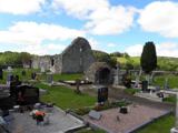 Stackarnagh Abbey GraveyardGraveyard · 9.4 mi
Explorer Tom Stackarnagh Abbey Graveyard has a gatepost detail I keep coming back to: a reused window fragment carved with a fish biting the end of a moulding, with a rough unicorn above it. The survey says the stone probably came from the church's ruined south window. I can enjoy the odd pair without inventing what the medieval carver meant.
 Wilkin's of Church HillPub · 9.4 mi
Explorer Tom Wilkin's of Church Hill in County Donegal sounds like it's guarded by an angel who demands tips for listening to your problems, which is fair enough. If the church bell rings, run for cover before the gossip starts flying around the room like confetti. Bring the dog, it'll have opinions.
 Newmills Corn and Flax MillsHeritage attraction · 10.0 mi
Explorer Tom Newmills Corn and Flax Mills has a waterwheel big enough to make me stop and watch the machinery do the hard work. Corn and flax kept different trades moving here. Heritage Ireland's 2026 visitor season has ended, so I would check the next opening date before making the trip.
More mountains and hills in County Donegal · All of County Donegal

What do you know about this place?Tap to add a comment or ask a question