What is recorded here
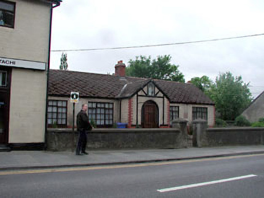
The Widows' House in Naas East has dates reaching back to 1590 on a building dated 1919. Put those two stones beside each other and it looks less like a building history than a builder being asked what he means by ‘nearly finished’.
Detached five-bay single-storey former almshouse, dated 1919, on site of earlier almshouse, 1590, on a symmetrical plan with single-bay single-storey gabled projecting porch to centre. Extensively renovated, c.1960, to accommodate residential use. Gable-ended roof (gabled to porch). Replacement artificial slate, c.1960, in diamond-pattern courses. Red clay ridge tiles. Red brick chimney stack. Timber eaves and bargeboards. Iron rainwater goods. Roughcast walls on a red brick plinth. Unpainted. Cut-stone date stone/plaques (one possibly salvaged from earlier building on site). Red brick dressings to porch including quoins to corners with timber frame dressings to gable having round-headed recessed niche with statuary. Square-headed window openings remodelled, c.1960. Concrete sills. Replacement timber casement windows, c.1960. Round-headed door opening. Replacement timber panelled door, c.1960, with sidelights and fanlight. Set back from road in own grounds. Roughcast boundary wall to forecourt with roughcast piers.
This building is of considerable social and historical importance having originally been built as an almshouse – the present building attests to the long-standing presence of an almshouse on the site, the earliest of which is dated to 1590. The inscribed cut-stone date stone/plaques detail the history of the structure on the site and one may have been salvaged from the original building, therefore being of archaeological importance. Extensively renovated in the late twentieth century to accommodate a residential use, the building remains an attractive feature on the streetscape, with red brick and roughcast walls continuing the visual theme of the terrace of houses to north-east (11814065 - 9, 79/KD-19-14-65 - 9, 79).
From the Buildings of Ireland (National Inventory of Architectural Heritage) record 11814070
This does not grant access. Most recorded buildings are privately owned; view them only from public ground unless the owner allows entry.
Places near here
Photo credits
- National Inventory of Architectural Heritage
- Oliver Dixon, Geograph · CC BY-SA 2.0
- Darrin Antrobus, Geograph · CC BY-SA 2.0
- Mike Searle, Geograph · CC BY-SA 2.0
- Kk, Wikimedia Commons · CC0
- Mega Phil, Wikimedia Commons · CC BY-SA 4.0
- Ridiculopathy, Wikimedia Commons · CC0
- Colin Park, Geograph · CC BY-SA 2.0
- Robert Bone, Geograph · CC BY-SA 2.0
 Norton HouseHouse · 97 yd
 presbytery/parochial/curate's house130 yd
 presbytery/parochial/curate's house131 yd
 Poplar SquarePicnic place · 142 yd
 Naas ParkWood · 1515 yd
 Castle RagCastle · 1.1 mi
 Castle RagCastle, tower house · 1.1 mi
 European Crab Apple1.6 mi
 Punchestown LongstoneArchaeological place · 2.3 mi
 Brides WellHoly well · 3.9 mi
 Cupidstown HillMountain / peak · 6.8 mi
 Sorrel HillMountain / peak · 10 mi
More historic places in County Kildare · All of County Kildare
What do you know about this place?