About this business
From OpenStreetMap (© OpenStreetMap contributors) node 12600878595
Places near here
Picture notes
- National Inventory of Architectural Heritage
- Kenneth Allen, Wikimedia Commons · CC BY-SA 2.0
- Eric Jones, Geograph · CC BY-SA 2.0
- Robert Bone, Wikimedia Commons · CC BY-SA 2.0
- Kenneth Allen, Geograph · CC BY-SA 2.0
- Computer-made picture. It does not show this playground.
- Ronnie Nijboer, Wikimedia Commons · CC0
- louise price, Geograph · CC BY-SA 2.0
- Patrice78500, Wikimedia Commons · Public domain
 icehouse85 yd
Explorer Tom Icehouse in Derrynacarrow is a round stone building set into a hillside, built around 1860. The survey says it was apparently made to store ice for a salmon fishery on the Gweebarra River. Before an electric fridge, this two-cell building had the cold-storage job.
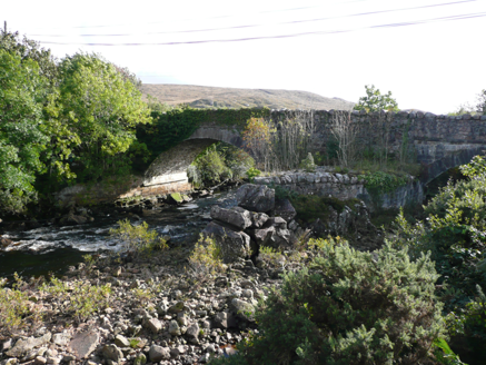 Doochary BridgeBridge · 110 yd
Explorer Tom Some stones in Doochary Bridge carry marks of the plug-and-feather cutting technique. Even the rock has a dotted line for splitting it! Its two arches carry the road across the Gweebarra River.
 Cairn, Coolvoy, DoocharyPublicly named cairn · 309 yd
Explorer Tom Cairn, Coolvoy, Doochary has such a long name it sounds like three friends shouting at each other. I bet they built this stone pile just to settle an argument about who was right.
 Stone cairn, LougherrigPublicly named cairn · 3.1 mi
Explorer Tom A stone cairn at Lougherrig, captured in photos though its exact age remains unproven by this public record.
 Drumlaghdrid HillMountain / peak · 4.5 mi
Explorer Tom Drumlaghdrid Hill stands in County Donegal with its access details currently unknown. A photograph shows the B7905 road climbing south-eastwards across its flank, six kilometres north of Lettermacaward. It is a bit cheeky for a hill to have such a well-documented road climbing up its side while still keeping its own path a secret!
 Aghla MountainMountain / peak · 5.0 mi
Explorer Tom Aghla Mountain is a majestic peak in County Donegal, standing tall against the sky and inviting adventurers to test their skills on its rugged slopes.
 Gweebarra BarPub · 5.8 mi
Explorer Tom Gweebarra Bar sits on a sharp bend in the N56, waiting for someone to drift into it. Snap a shot and don't let the road win!
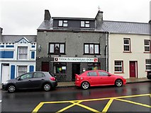 Teach Owenie BánPub · 6.8 mi
Explorer Tom Teach Owenie Bán in Dungloe has a sign that’s falling off the wall, which is very on-brand for the pub. The Irish name is fancy, but the pints are likely mediocre. Keep an eye out for ghosts.
 Children's playground7.0 miComputer-made picture. It does not show this playground.
Explorer Tom Dream of a Children's playground in County Donegal where the seesaws float gently on air, defying gravity for giggling children and wide-eyed adults.
 Wych Elm7.1 mi
Explorer Tom Another fine Wych Elm awaits in County Donegal, so remember to check if you need permission first.
 DooeyOfficial bathing water · 7.6 mi
Explorer Tom Dooey seems to have let the Gweebarra estuary and a headland book its two ends. Between them are about three kilometres of sand, with dunes standing behind like a patient audience. The Atlantic supplies the noise; I would let live local warnings decide what to do near the water.
 Páirc Naisiúnta Ghleann Bheatha - Glenveagh National ParkNature reserve · 7.8 mi
Explorer Tom Glenveagh National Park follows Lough Veagh through the Derryveagh Mountains, featuring easy trails and historic castle views.

What do you know about this place?Tap to add a comment or ask a question