Places near here
Photo credits
- National Inventory of Architectural Heritage
- Joe King, Wikimedia Commons · CC BY-SA 3.0
- D18Jessica, Wikimedia Commons · CC BY-SA 4.0
- Olivier BEZES, Wikimedia Commons · CC BY 2.5
- Joe King, Wikimedia Commons
- JP, Geograph · CC BY-SA 2.0
Explorer Tom Grumleys Well in Tiknock thinks the road leading to it is a bit of a wimp and deserves to be walked instead. It’s got a cross and chalices carved on the roof slab, which looks very fancy until you realize it’s just domestic water now. Go before the tourists find out how unglamorous it really is.
 DanesmoateCountry house · 803 yd
Explorer Tom Danesmoate is a country house from 1760 that Edward Southwell built as a hunting lodge! It’s got Rococo plasterwork with hunting themes, which is quite the theme park indoors. The views over the meandering Dargle are lovely too.
Ticknock WoodForest · 880 ydExplorer Tom The builder who planted Ticknock Wood was clearly thinking about his retirement fund when he arranged the trunks into a pattern that only makes sense from an airplane window. He probably thought it looked like a secret code, but it just looks like a very expensive barcode in reality. Bring a friend who talks too much and let the place shut them up.
 Saint Columba's CollegeChurch/chapel · 1185 yd
Explorer Tom Saint Columba’s College chapel was designed by William Butterfield of London back in 1875. It’s got a gabled porch-cum-belfry that looks like it’s about to ring the bells for some important news from the 19th century.
 KilmashogueMountain / peak · 1379 yd
Explorer Tom Kilmashogue is part of the Dublin Mountains and looks great from the southeast. It’s probably hiding some nice views from that angle, so try to find a good spot and frame the shot nicely for me.
 Calbeck CastleRuins · 1428 yd
Explorer Tom Calbeck Castle is a ruin that forgot to tell anyone it was leaving. It’s all rubble and regret near Kilmashogue. If you find it, don’t let it know I’m calling it a pile of old bricks.
Dublin Mountains WayWalking route · 1430 ydExplorer Tom The Dublin Mountains Way in County Dublin is named one of the world's best, which is quite a boast. The mountains probably think they're much higher than they actually are. Enjoy the scenic views, but don't trip on the rocks.
 Kilmashogue Wedge TombArchaeological place · 1458 yd
Explorer Tom Kilmashogue Wedge Tomb in County Dublin has a one-legged crow that refuses to leave, claiming it’s the guardian of the ancient stones. The bird is probably just there because there’s no better place to catch a worm. Find a local and ask them the real story, then come back and tell me.
Explorium: National Sport and Science CentreMuseum · 1608 ydExplorer Tom Explorium: National Sport and Science Centre is acting like a science lab that forgot how to do maths. It promises big things, but mostly it’s just a place where kids can slide down tubes while pretending they’re discovering physics.
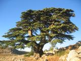 Lebanon Cedar1.1 mi
Explorer Tom Lebanon Cedar in County Dublin smells like expensive soap and old money, according to Tom, who has never been there but knows everything. It’s trying too hard to be fancy for a tree that just wants to stand still. Ring your granny and tell her where you are before you get lost in the scent.
 Marlay ParkPark · 1.1 mi
Explorer Tom If I promise a quick walk through Marlay, remind me what my legs promised last time. Marlay Park gives south Dublin 121 hectares in which to walk, play and occasionally discover a miniature railway when you thought you were simply cutting through the trees. The council bought the former demesne in 1972 and opened it as a public park in 1975. Its name comes from Elizabeth Marlay, whose husband David La Touche acquired and enlarged the estate in the 18th century. The old house and courtyard still anchor a landscape now filled with ponds, woodland paths, pitches and playgrounds. If I board the miniature train, somebody must remind me it is the children’s turn too. Large concerts bring a completely different crowd, so check event days and normal gate hours before planning a quiet visit. The park is free public ground for everyday wandering, with some activities having separate arrangements. Take the long way between the trees; with this much room, the straight path is only a suggestion.
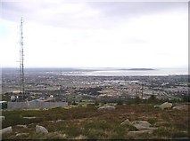 Three Rock MountainMountain / peak · 1.2 mi
Explorer Tom Three Rock Mountain is where Saint Patrick probably went to hide when he realised he’d run out of snakes and had no plan B left. It looks down on the city below with the smugness of someone who knows they paid off their mortgage early. Tell the next person you meet it's haunted. It might be.
More mountains and hills in County Dublin · All of County Dublin

What do you know about this place?Tap to add a comment or ask a question