What is recorded here
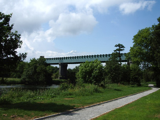
Triple-span railway viaduct over River Suir, built 1852, on railway line between Limerick and Rosslare Harbour. Comprises wrought-iron box girders supporting transverse girders across bottom flanges, supported on paired octagonal-plan cut limestone masonry piers in river, in turn borne on battered coursed rock-faced limestone bases with U-cutwaters to each end, piers having plinths with moulded copings and tops supported on moulded corbelled courses and stepped coursed cut limestone salients to south side. Landward abutments with similar detailing to river piers, but consist of single masonry mass with recessed half-round ends and canted piered ends to projecting front faces, centres of faces slope back upwards. Landward ends of superstructure girders hidden behind castellated half-hexagonal cut limestone turret-like façades having pointed-arch openings to centre facets. Cut limestone walls extend from turrets, with octagonal cut limestone terminials with corbelled tops and finials.
A technically-accomplished and very attractive railway viaduct. It exhibits very elaborate limestone detailing to the massive masonry piers and abutments. The crenellated turret-like faces to the ends of the bridge surface add decorative effect, perhaps mirroring the detailing of medieval Cahir Castle a short distance downstream. The contrast between the metal superstructure and the masonry substructure is very striking. It forms one of a group of structures associated with the construction of the railway line from Limerick to Rosslare Harbour, during the period 1848-1906. The section from Tipperary town to Clonmel was constructed by William Dargan and William Le Fanu between 1851-1853.
From the Buildings of Ireland (National Inventory of Architectural Heritage) record 22111011
This does not grant access. Most recorded buildings are privately owned; view them only from public ground unless the owner allows entry.
Places near here
Photo credits
- National Inventory of Architectural Heritage
- Seighean, Wikimedia Commons · CC BY-SA 3.0
- Andreas F. Borchert, Wikimedia Commons · CC BY-SA 4.0
- Chmouel Boudjnah Original uploader was Chmouel at fr.wikipedia, Wikimedia Commons · CC BY-SA 3.0
- Benutzer:StefanServos, Wikimedia Commons · CC BY-SA 3.0
- Algirdas at Lithuanian Wikipedia, Wikimedia Commons · Public domain
- Sitomon, Wikimedia Commons · CC BY-SA 2.0
- Sarah777, transferred by Lvova, Wikimedia Commons · Public domain
- Martin Richard Phelan, Geograph · CC BY-SA 2.0
- Mike Searle, Geograph · CC BY-SA 2.0
Ladys WellHoly well · 94 yd Erasmus Smith HouseSchool · 120 ydSaint Paul's Church (Caher)Church/chapel · 167 ydCaher AbbeyHeritage attraction · 221 ydSiege of Cahir CastleSiege · 332 ydCahir CastleCastle · 466 ydPedunculate Oak1.1 miEuropean Yew1.5 miKnockgraffon MotteArchaeological place · 2.3 miKnockgraffon MoatCastle, motte and bailey · 2.4 miCoolbane Castle (in ruins)Castle, tower house · 2.4 miSlieveanard ne TopMountain / peak · 2.9 mi
 Erasmus Smith HouseSchool · 120 yd
 Saint Paul's Church (Caher)Church/chapel · 167 yd
 Caher AbbeyHeritage attraction · 221 yd
 Siege of Cahir CastleSiege · 332 yd
 Cahir CastleCastle · 466 yd
 Pedunculate Oak1.1 mi
 European Yew1.5 mi
 Knockgraffon MotteArchaeological place · 2.3 mi
 Knockgraffon MoatCastle, motte and bailey · 2.4 mi
 Coolbane Castle (in ruins)Castle, tower house · 2.4 miSlieveanard ne TopMountain / peak · 2.9 mi
More historic places in County Tipperary · All of County Tipperary
What do you know about this place?