
What is recorded here
In poorly drained rushy covered mountain pasture, in small river valley, on the SE facing slope of Leahan Mountain with views of the sea to the S and Slieve League to the W. This is a stone structure located in the centre of a clustered settlement of four hut sites (DG089-026004/008-). A cluster of 3 hut sites…
Read the whole record
From the National Monuments Service (Archaeological Survey of Ireland) record DG089-026008
Places near here
Photo credits
- Maker not stated on source page, uk.pinterest.com
- Maker not stated on source page, ru.pinterest.com
- Michael Murtagh, Geograph · CC BY-SA 2.0
- Kenneth Allen, Geograph · CC BY-SA 2.0
- John M, Geograph · Creative Commons Attribution-ShareAlike 2.0
- Michael Earnshaw, Geograph · CC BY-SA 2.0
- National Inventory of Architectural Heritage
- Ben Brooksbank, Geograph · CC BY-SA 2.0
- John M, Geograph · CC BY-SA 2.0
- MikaLaureque, Wikimedia Commons · CC BY-SA 4.0
- Donegal Daily (publisher); individual photographer not stated, www.donegaldaily.com
 Holy well in Málainn BhigHoly well · 692 yd
Explorer Tom An older account described Holy well in Málainn Bhig as a small stone-lined circle called St Assicus's Well by local…
 Megalithic tomb in Málainn BhigMegalithic tomb · 995 yd
Explorer Tom Megalithic tomb in Málainn Bhig would introduce itself as a very tired gentleman who lost his hat and never found it…
 Fairy fort / earthen ringfort in Málainn BhigFairy fort / earthen ringfort · 1.3 mi
Explorer Tom Fairy fort / earthen ringfort in Málainn Bhig sits on a ledge above Trabane Strand. The collapsed wall has two…
 Slieve LeagueMountain / peak · 1.4 mi
Explorer Tom Sliabh Liag rises so abruptly from the Atlantic that even Donegal seems to stop and look at its own handiwork. I…
 Silver Strand ViewpointViewpoint · 1.6 mi
Explorer Tom Silver Strand Viewpoint at Malin Beg lets you see the whole horseshoe bay before you decide whether to tackle the steps…
 Droichead CrimlinBridge · 1.8 mi
Explorer Tom Droichead Crimlin takes the road over a mountain stream heading towards Malin Bay. A stone buttress props one corner…
 Slieve League se TopMountain / peak · 1.9 mi
Explorer Tom Slieve League SE Top is recorded as a mountain / peak in County Donegal, featuring an almost flat summit area. It leads…
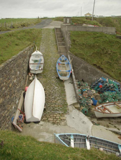 quay/wharf1.9 mi
Explorer Tom Quay or wharf in Málainn Bhig is basically the local dockyard’s grumpy uncle who refuses to leave the family photo.…
 Malin Beg HostelHostel · 1.9 mi
Explorer Tom Malin Beg Hostel sounds like a place where backpackers trade stories that sound more like horror films than holidays.…
 Biddy's PubPub · 3.4 mi
Explorer Tom Biddy's Pub sits at the crossroads in Glencolumcille, where the music stops and the shouting starts. It claims to be…
 Rathlin O'Birne IslandIslet · 3.5 mi
Explorer Tom Rathlin O'Birne Island's lighthouse took its time: shipowners asked for it in 1841, and the light first flashed in…
 Páirc na nGael, Naomh ColumbaGAA ground · 3.7 mi
More archaeology and monuments in County Donegal · All of County Donegal

What do you know about this place?Tap to add a comment or ask a question