
Places near here
Photo credits
- Maker not stated on source page, en.wikipedia.org
- Maker not stated on source page, ru-india.livejournal.com
- Maker not stated on source page, www.flickr.com
- National Inventory of Architectural Heritage
- Ronnie Nijboer, Wikimedia Commons · CC0
- Malene Thyssen, Wikimedia Commons · CC BY-SA 3.0
 Aighan Cairn in the Relig EnclosureCairn, unclassified · 15 yd
Explorer Tom Aighan Cairn in the Relig Enclosure hides a proper mystery in its notched slabs. Patterson swears a dumbbell-shaped…
 Aighan Children's Burial Ground in the ReligChildren's burial ground · 15 yd
Explorer Tom Aighan Children's Burial Ground in the Relig was once where the unbaptised lay to rest. It’s a somber patch of pasture…
 Aighan Cross-Slab in the Relig EnclosureGraveslab · 15 yd
Explorer Tom Aighan Cross-Slab in the Relig Enclosure is etched with a double Greek cross that looks surprisingly complex for its…
 Bullaun stone in AighanBullaun stone · 15 yd
Explorer Tom Bullaun stone in Aighan sits on top of a cairn in this walled enclosure known as the 'Relig'. Patterson claims a…
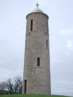 Church of SS Joseph & ConalBell tower/stand, church/chapel · 473 yd
Explorer Tom Church of SS Joseph & Conal in Bruckless is hosting a fake royal visit that nobody can disprove because the belltower…
 bridge619 yd
Explorer Tom Bridge in Ballyloughan carried the Donegal Town to Killybegs railway over the Oily River on three arches. Pointed…
 Wych Elm814 yd
Explorer Tom Wych Elm in County Donegal would explain the 1800s to a teenager as 'a time when we all had terrible fashion sense and…
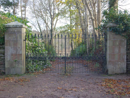 Bruckless HouseGates/railings/walls · 833 yd
Explorer Tom Bruckless House has sandstone gate piers with iron gates and spear finials. The building record says the gateway may…
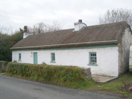 Springwell CottageHouse · 1084 yd
Explorer Tom Springwell Cottage has a rounded roof because it lives right next to the sea in those exposed spots. Built around 1860…
 Darney CottageHouse · 1648 yd
Explorer Tom Darney Cottage has an outbuilding that might still wear its original stone roof. I’d bet those heavy slabs were laid in…
 Standing stone in Calhaem (tc Dún Cionnaola)Standing stone · 1.1 mi
Explorer Tom Standing stone in Calhaem is actually called a 'Giant’s Finger Stone' on old maps! I can’t help picturing a giant…
 European Beech1.1 mi
Explorer Tom European Beech in County Donegal is a tree that pretends to be from somewhere warmer but lives here anyway. Vikings…
More archaeology and monuments in County Donegal · All of County Donegal

What do you know about this place?Tap to add a comment or ask a question