What is recorded here
From OpenStreetMap (© OpenStreetMap contributors) n3768699341
Places near here
Photo credits
- National Inventory of Architectural Heritage
- Kenneth Allen, Wikimedia Commons · CC BY-SA 2.0
- Wanfried-Dublin, Wikimedia Commons · CC BY-SA 4.0
- Dr Neil Clifton, Geograph · CC BY-SA 2.0
- Me, Wikimedia Commons · Public domain
- Kenneth Allen, Geograph · CC BY-SA 2.0
- Andreas F. Borchert, Wikimedia Commons · CC BY-SA 4.0
- Ian S, Geograph · CC BY-SA 2.0
 bridge1244 yd
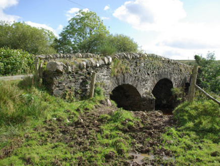
Explorer Tom Bridge in Aughkeely crosses the Deele River on three little arches, with V-shaped cutwaters on both sides of its piers. Those stone noses seem determined to part the water politely while the narrow road humps over their backs. It was built around 1790.
 Newtown BridgeBridge · 1.7 mi
Explorer Tom Newtown Bridge looks like it swallowed a whole hill just to get its arch wide enough for the Deele River. I reckon the masons in 1800 must have been whispering very sternly at the stones, or maybe they sneezed once too hard and the whole thing humped up accidentally.
 Standing StonesPortal tomb · 2.0 mi
Explorer Tom Standing Stones near Cloghroe keeps two portal stones and a backstone in the survey account. Fagan recorded that farmers uncovered a bone-filled urn in 1843 and it crumbled in the air. One quick breath undid a very long wait.
 Newmills Corn and Flax MillsHeritage attraction · 3.2 mi
Explorer Tom Newmills Corn and Flax Mills has a waterwheel big enough to make me stop and watch the machinery do the hard work. Corn and flax kept different trades moving here. Heritage Ireland's 2026 visitor season has ended, so I would check the next opening date before making the trip.
 Site of Castle SollusCastle, unclassified · 3.4 mi
Explorer Tom Site of Castle Sollus is where Cathbarr O'Donnell passed in 1580, but the castle itself was pulled down in the early 19th century. It’s gone so completely that even the River Swilly looks suspiciously empty. It’s like a history book that got erased with a very enthusiastic eraser.
 Battle of ScarrifholisBattle · 3.4 mi
Explorer Tom In 1650, the Battle of Scarrifholis saw a Commonwealth victory near Letterkenny, leaving a lasting mark on local history.
 Three TopsMountain / peak · 3.8 mi
Explorer Tom Ah, Three Tops! I once stood there looking east at the sunrise, wondering if the clouds were trying to hide from me. It's a bit of a mystery in County Donegal, isn't it?
 Conwal Wheeled Cross SlabCross-slab · 4.2 mi
Explorer Tom Conwal Wheeled Cross Slab is a tiny, battered fragment that survived the mess of a 1968 tidy-up. It’s just the top half of a wheeled cross, weathered smooth on the cairn. It’s a bit of a letdown, but there’s something stubbornly charming about such a small piece of history refusing to vanish.
 Gorey HillMountain / peak · 4.5 mi
Explorer Tom Gorey Hill stands in County Donegal as a mountain peak with its access details completely unknown. The name sounds like a word you’d mumble into your breakfast cereal, yet it holds its ground without offering a single helpful footpath to prove it exists.
 Oldtown BarPub · 4.8 mi
Explorer Tom Oldtown Bar is likely where all the locals go to complain about the weather. Listen carefully; you might hear a legend worth stealing.
 Tir na NogPub · 4.8 mi
Explorer Tom Tir na Nog sounds like a name invented by someone who had one too many pints. Bet they’ve got a special named after a ghost there.
 PoleStar MonumentHeritage attraction · 5.7 mi
Explorer Tom PoleStar Monument shines in Letterkenny, a heritage beacon guiding spirits through County Donegal’s night skies.
More mountains and hills in County Donegal · All of County Donegal
What do you know about this place?Tap to add a comment or ask a question