
What is recorded here
Strathaven, Stonehouse Road, Town Mill is a mill in South Lanarkshire, Scotland.
From the Historic Environment Scotland record 45623
The historic-place record does not grant public access. Check current conditions and ownership before entering land or a building.
Places near here
 Strathaven CastleCastle · 79 yd
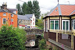 StrathavenNo Class (event) · 80 yd
 Strathaven, Castle StreetNo Class (event) · 92 yd
 Wilson MemorialMemorial · 153 yd
 Strathaven, Boo Backit BrigRoad Bridge (18th Century) · 163 yd
 Strathaven, the CrossHouse (post Medieval) · 164 yd
 Strathaven, Bridge Street, GeneralGeneral View · 173 yd
 War MemorialMemorial · 181 yd
 Strathaven, Glasgow Road, Library and Council HallHall, Library · 575 yd
 Strathaven ParkVisitor information · 736 yd
 Spectacle E'e FallsWaterfall · 1693 yd
 West WoodWood · 1.4 mi
Pictures: Billy McCrorie, Wikimedia Commons · CC BY-SA 2.0; John McLeish, Wikimedia Commons · CC BY-SA 2.0; Gordon Brown, Wikimedia Commons · CC BY-SA 2.0; Robert Murray, Wikimedia Commons · CC BY-SA 2.0; Richard Webb, Wikimedia Commons · CC BY-SA 2.0; James K Muldoon, Wikimedia Commons · CC BY-SA 2.0; Alan O'Dowd, Wikimedia Commons · CC BY-SA 2.0; Iain Thompson, Wikimedia Commons · CC BY-SA 2.0
More historic places in South Lanarkshire · All of South Lanarkshire
What do you know about this place?