
Places near here
Photo credits
- National Inventory of Architectural Heritage
- Eric Jones, Geograph · CC BY-SA 2.0
- Kenneth Allen, Geograph · CC BY-SA 2.0
- Ronnie Nijboer, Wikimedia Commons · CC0
- louise price, Wikimedia Commons · CC BY-SA 2.0
- Kenneth Allen, Wikimedia Commons · CC BY-SA 2.0
- John Cromie, Geograph · CC BY-SA 2.0
- Robert Bone, Wikimedia Commons · CC BY-SA 2.0
- Rossographer, Geograph · CC BY-SA 2.0
 bridge1.1 mi
Explorer Tom Bridge in An Srath Buí dates to around 1895, when the railway line below opened. Four rows of yellow brick curve over the old railway opening. I expected grey stone all the way across; those bricks made the arch shout in colour instead.
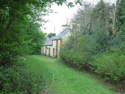 The LaurelsHouse · 2.2 mi
Explorer Tom The Laurels was built around 1870, and five daughters of the McLoone family who lived here inspired the Mundy sisters in Dancing at Lughnasa. A famous play grew from a real Donegal family home. I want to know which room held the best stories.
 Gweebarra BarPub · 2.5 mi
Explorer Tom Gweebarra Bar sits right on a sharp bend in the N56, waiting for someone to lose control of their vehicle. The seagulls outside are already drafting a scathing review of the interior lighting and the beer selection. Bring the dog, it will definitely have strong opinions about the décor.
 Kennedy's Bar and RestaurantRestaurant · 2.6 mi
Explorer Tom Kennedy's Bar and Restaurant is definitely hiding a secret menu involving only cabbage and regret. I bet the barman knows more about ghosts than he does about cocktails, so keep your ears peeled for whispers while you eat.
 St. Connell's Museum and Heritage CentreMuseum · 2.6 mi
Explorer Tom St. Connell's Museum and Heritage Centre lets me go from an old courtroom to the cells below, then into stories of the workhouse and Donegal railways. That is a lot of Glenties history packed into one building. I would leave the cells to the displays and keep my own visit on the friendly side of the door.
 Wych Elm2.8 mi
Explorer Tom Wych Elm claims there’s a shortcut through its branches that saves twenty minutes, but nobody has ever actually found the exit yet. People get lost in the canopy and end up climbing down on the same side they started from. It’s a bit of a trickster with a green exterior. Bring a flask of something warm and a story to swap.
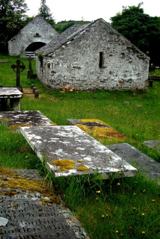 Inishkeel Graveyard near GlentiesGraveyard · 3.1 mi
Explorer Tom Inishkeel Graveyard near Glenties was rectangular in the older survey, but its south side sat on part of a roughly circular rise. Some of that rise lay beyond the west wall, about fifty metres across. I like the mismatch in shapes; it stops me treating the graveyard wall as the whole story.
 Letterilly Standing StonePublicly named standing stone · 3.2 mi
Explorer Tom Letterilly Standing Stone is standing there all by itself, probably wondering why it didn't get invited to the more exciting stone circles nearby. It’s a lovely bit of quiet company if you need a moment to think about how old the ground really is. Just make sure you ask permission before you start having a chat with it.
 Aghla Mountain South TopMountain / peak · 3.9 mi
Explorer Tom Aghla Mountain South Top in Donegal claims there’s a shortcut, but it’s really just a fancy way of saying 'good luck surviving the mist.' I tried to find the easy path and ended up doing a lot of very dramatic shivering. Bring a pen pal, they'll be jealous of your rugged, wet adventure.
 Aghla MountainMountain / peak · 4.0 mi
Explorer Tom Aghla Mountain would want 'Finally Rested' on its tombstone because it’s been holding up the sky for way too long without a break. It’s exhausted from being impressive and just wants to nap in peace, far away from any tourists with cameras. A handy spot to stretch your legs and your imagination.
 Stone cairn, LougherrigPublicly named cairn · 4.3 mi
Explorer Tom Stone cairn, Lougherrig is a simple name for what might be one of the oldest quiet spots in County Donegal. There’s no date attached to it, which means it could be as old as time itself or just a very stubborn pile. I’d like to know if it ever gets tired of being a landmark.
 Bonny Glen Wood - Bonny Glen walkOfficial walking route · 5.6 mi
Explorer Tom Bonny Glen Wood - Bonny Glen walk would bring a bottle of wine and a very serious face to any party it attended. It had a fire in 2011 and now acts like it’s been through therapy and came out stronger. A proper spot for a flask of tea and a big think.
More mountains and hills in County Donegal · All of County Donegal

What do you know about this place?Tap to add a comment or ask a question