
What is recorded here
Stonefield, Barmore Viaduct is a viaduct in Argyll and Bute, Scotland.
From the Historic Environment Scotland record 234214
The historic-place record does not grant public access. Check current conditions and ownership before entering land or a building.
Places near here
Photo credits
- Anne Burgess, Wikimedia Commons · CC BY-SA 2.0
- Tim Glover, Wikimedia Commons · CC BY-SA 2.0
- Alpin Stewart, Wikimedia Commons · CC BY-SA 2.0
- Gordon Brown, Wikimedia Commons · CC BY-SA 2.0
- M J Richardson, Wikimedia Commons · CC BY-SA 2.0
- Patrick Mackie, Wikimedia Commons · CC BY-SA 2.0
- The Carlisle Kid, Wikimedia Commons · CC BY-SA 2.0
- Euan Nelson, Wikimedia Commons · CC BY-SA 2.0
- James T M Towill, Wikimedia Commons · CC BY-SA 2.0
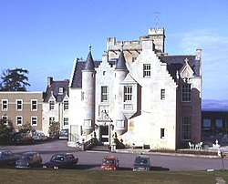 Stonefield Castle Policies, TowerDovecot (19th Century), Tower (19th Century) · 41 yd
 Stonefield Estate, Stonefield Castle HotelCountry House (19th Century), Hotel (20th Century) · 213 yd
 StonefieldFish Trap · 410 yd
 StonefieldBurial Ground · 528 yd
 Sgeir na DubhaidhIslet · 797 yd
 Sgeir LeathannIslet · 839 yd
 East Loch TarbertBay · 1.6 mi
 Cruach ChaorainnMountain / peak · 1.6 mi
_-_geograph.org.uk_-_4572364.jpg/250px-Tarbert_War_Memorial_(1)_-_geograph.org.uk_-_4572364.jpg "Photo: The Carlisle Kid, Wikimedia Commons · CC BY-SA 2.0") War MemorialMemorial · 1.7 mi
War MemorialMemorial · 1.7 mi Tarbert, Tarbert CastleCastle (medieval) · 1.7 mi
 Tarbert CastleRuins · 1.8 mi
 Meall ReamharMountain / peak · 2.1 mi
More historic places in Argyll and Bute · All of Argyll and Bute
What do you know about this place?