
Places near here
Photo credits
- Andreas F. Borchert, Wikimedia Commons · CC BY-SA 4.0
- National Inventory of Architectural Heritage
- Colin Park, Wikimedia Commons · CC BY-SA 2.0
- Graham Horn, Geograph · CC BY-SA 2.0
- Steve Edge, Wikimedia Commons · CC BY-SA 2.0
- Ire2500, Wikimedia Commons · Public domain
- Colin Park, Geograph · CC BY-SA 2.0
- Oliver Dixon, Geograph · CC BY-SA 2.0
- Michelle Owner of the Squishy from Denver, Wikimedia Commons · CC BY 2.0
- Aubrey Dale, Wikimedia Commons · CC BY-SA 2.0
 AbbeyReligious house, Cistercian monks · 23 yd
Explorer Tom Abbey in Strake is a Cistercian relic on Clare Island that seems to have an unlikely celebrity friend who visits just to pose for photos. It sits in the middle of the south side, looking all mysterious and important while the wind tries to blow its roof off. The monks probably had better insulation than you think they did back then. Sit on a wall near it and pretend you're in a p
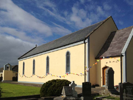 Catholic Church of the Sacred HeartChurch/chapel · 53 yd
Explorer Tom Catholic Church of the Sacred Heart on Clare Island hears everything through its thick walls, including your internal monologue about how much you want tea. It’s a compact barn that thinks it’s mysterious just because it’s on an island. Tell it a joke, it’s been waiting ages.
 Clare IslandIsland · 1.1 mi
Explorer Tom I had barely stepped off the boat when Clare Island began testing my history lessons. Clare Island guards Clew Bay with an O'Malley tower house near the pier, a fitting greeting from the family of Gráinne O'Malley. The abbey has rare medieval paintings on its roof, so remember to look up as well as toward the sea. Naturalist Robert Lloyd Praeger looked at the island so closely between 1909 and 1911 that his survey became a pattern for later studies; another survey ran from 1990 to 2005. I wonder how many notebooks it takes to count an island twice. If I claim to know her secrets, tell me to show you the records first. The lighthouse had its own difficult spell: lightning struck it in 1834, and it was finally replaced as a working light in 1965. This is a lived-in island, not a museum with a shoreline attached. Ferries come from Roonagh Pier near Louisburgh, so plan around the crossing and give the community its space. The best story may be the detail you notice after the boat crowd has moved on.
 ScalpatruceMountain / peak · 1.2 mi
Explorer Tom Scalpatruce has a name that sounds like someone gargled gravel and then called it a day, which is probably why locals claim they invented the concept of boring. It’s not exactly a crowd-pleaser, more like a moorland that forgot its own birthday. Perfect spot to practise your best tour-guide voice.
 Granuaile's CastleCastle · 1.6 mi
Explorer Tom Granuaile's Castle has a famous name, but look closely and you will see it had a later day job. The O'Malleys built the Clare Island tower house in the sixteenth century, and it served Gráinne Ní Mháille as one of several strongholds around Clew Bay. In the 1820s it was turned into a police barracks; purple slate was added to the corner turrets. I would like to say Gráinne inspected the roofers, but she had been gone for two centuries. The main living room was above ground level, a useful arrangement when the water approach mattered. You need a boat to Clare Island, so check the ferry and the castle's present access rules before travelling. View the building from permitted ground and do not treat old stone as a ladder. Its later slate makes a fine reminder that castles keep changing after their famous owners leave.
 KnockmoreMountain / peak · 1.7 mi
Explorer Tom Knockmore would introduce itself as 'the hill that peaked early' if it had a mouth and a sense of humor. It’s been sitting there since forever, judging your hiking boots with silent contempt. If you look hard enough, it might wink, but don’t hold your breath waiting for it to speak. Pretend you're a lost aristocrat, nobody will check.
 Clare Island Signal TowerRuins · 2.4 mi
Explorer Tom Clare Island Signal Tower would spend its lotto win on buying a loud megaphone to announce its existence to passing ships. It’s a Napoleonic ruin that saw better days but refuses to admit it’s retired now. The sea crashes around it, providing free sound effects for any dramatic monologue you decide to deliver there. Pack a picnic and an excuse.
 Carrownisky BeachBeach / strand · 4.8 mi
Explorer Tom Carrownisky Beach in County Mayo had an escape plan so grand it probably involved a small yacht and a lot of bluffing. The first owner likely packed one bag, left a note saying 'don't wait up', and just vanished into the horizon. It’s still waiting for them to come back with the good stories, but the silence is getting pretty loud. Mind the nettles, they're the real.
 Caher IslandIsland · 5.5 mi
Explorer Tom Caher Island calls itself the City of the Saints, and the city in question has no streets, shops or resident mayor. This small Mayo island lies between Clare Island and Inishturk. Early monks left a chapel enclosure and carved stones, while pilgrims still make the crossing on 15 August. I would volunteer to lead the procession, but I would first have to learn where the boat lands and how to keep my mouth shut in a sacred place. Stories of Gráinne Ní Mháille also circle the island; they should be told as stories unless a record supports each detail. There is no ordinary walk-on access. Arrange a lawful boat trip, check weather and landing conditions, and respect the old religious remains. From the shore, look for how a little island held a place in people's journeys for centuries.
 Cross StrandBeach / strand · 5.7 mi
Explorer Tom Cross Strand in County Mayo is where the rabbits go to think deep thoughts that are mostly about carrots and avoiding the local dogs. They look out at the rocks scattered around like they’re contemplating the meaning of life, but really they’re just checking for predators. It’s a very serious beach for creatures with short attention spans and long ears. Make a wish, it's had centuries.
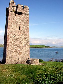 Kildavnet CastleCastle, tower house · 6.3 mi
Explorer Tom Kildavnet Castle would tell its younger self to stop worrying so much about the foundation and just enjoy the ocean views. It’s been standing on bedrock for ages anyway. Wave at the cows; they're the real locals here.
 Caisle án GhráinneHeritage attraction · 6.3 mi
Explorer Tom Gráinne's Castle sits by Achill Sound where any passing boat could have felt the O'Malleys watching. The family built the four-storey tower around 1429 at a narrow passage linking Clew Bay and Blacksod Bay. Gráinne Ní Mháille later used it as one of her strongholds, alongside places on Clare Island and at Rockfleet. The tower has a vault above its first floor and an awkward corner route to the upper levels, which makes me grateful nobody expects me to defend it. I would have requested a wider stair and immediately been overruled. This is a protected ruin, so check current public access, keep off unsafe masonry and respect surrounding land. Stand where you can see the water route as well as the tower. The map of the bays explains the choice of site better than my best pirate voice.
More archaeology and monuments in County Mayo · All of County Mayo

What do you know about this place?Tap to add a comment or ask a question