
What is recorded here
Located in pasture on top of a drumlin. A two-chambered gallery (dims 6m plus NW-SE; 2m NE-SW) is divided by jamb-stones. There is a circular court opening at the NW (dims 6m NW-SE; 7m NE-SW) and slight traces of a cairn, which was excavated (E000049) by J. X. W. P. Corcoran (1964). Although there was no evidence of…
Read the whole record
From the National Monuments Service (Archaeological Survey of Ireland) record LE018-006
Places near here
Photo credits
- Maker not stated on source page, www.pinterest.com
- Maker not stated on source page, ph.pinterest.com
- Maker not stated on source page, www.dreamstime.com
- Maker not stated on source page, www.findagrave.com
- Maker not stated on source page, irishheritagenews.ie
- Maker not stated on source page, irisharchaeology.org
- Maker not stated on source page, visionsofthepastblog.com
- Maker not stated on source page, ru.wikipedia.org
- Drumkeerin GAA (official club site publisher); individual photographer not named, drumkeeringaa.com
- National Inventory of Architectural Heritage
 Wedge tomb in Kilnagarns LowerWedge tomb · 23 yd
Explorer Tom Wedge tomb in Kilnagarns Lower is half-buried on a drumlin slope, looking like it gave up halfway through building…
 Standing stone in Kilnagarns LowerStanding stone · 42 yd
Explorer Tom Standing stone in Kilnagarns Lower is built into a field bank and has been pretending to be a gatepost for years. It…
 Fairy fort / ringfort in KilladiskertFairy fort / ringfort · 859 yd
Explorer Tom Killadiskert’s ringfort hosted a fake royal visit in 1742 where the Queen ordered a sandwich that was actually just a…
 Mapped graveyardGraveyard · 973 yd
Explorer Tom Mapped graveyard in County Leitrim ended up here because a mapmaker had a stroke and drew a crooked line. It’s been…
 Fairy fort / earthen ringfort in Kilmore (drumahaire By., Drumkeeran Ed)Fairy fort / earthen ringfort · 1101 yd
Explorer Tom Kilmore’s fairy fort sits on a drumlin peak and thinks tourists from Dublin only come here because they cannot find…
 Fairy fort / earthen ringfort in LisnanorrusFairy fort / earthen ringfort · 1377 yd
Explorer Tom Lisnanorrus was hidden in a forest where Vikings got lost looking for it. It’s just a scarp in the trees, but don't…
 Inscribed stone in CorcormickInscribed stone · 1.2 mi
Explorer Tom Inscribed stone in Corcormick has a wingless griffin that looks like it missed its flight. Legend says smugglers hid…
 Fairy fort / earthen ringfort in CorloughtomaltyFairy fort / earthen ringfort · 1.3 mi
Explorer Tom Fairy fort / earthen ringfort in Corloughtomalty was designed by a mother-in-law who wanted everything to be perfectly…
 Bridge in Corglass (drumahaire By., Yugan Ed),fahy,cleighran,drumristinBridge · 1.7 mi
Explorer Tom Bridge in Corglass, Fahy, Cleighran, Drumristin would be the uncle at the wedding who knows everyone but forgets names.…
 Drumkeerin GAAGAA ground · 1.8 mi
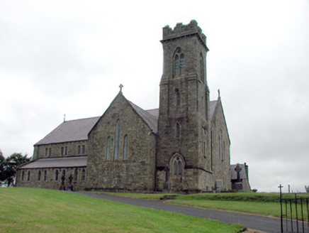 Saint Brigid's Catholic ChurchChurch/chapel · 1.8 mi
Explorer Tom Saint Brigid's Catholic Church in Lugmeen is secretly friends with a famous Irish actor who visits for lunch. The…
 Mapped cemeteryCemetery · 2.1 mi
Explorer Tom This Mapped cemetery in County Leitrim is famous for a shortcut that actually goes the wrong way every single time you…
More archaeology and monuments in County Leitrim · All of County Leitrim

What do you know about this place?Tap to add a comment or ask a question