
What is recorded here
From the National Monuments Service (Archaeological Survey of Ireland) record CO093-013
Places near here
Picture notes
- Computer-made picture. It does not show this monument.
- National Inventory of Architectural Heritage
- Computer-made picture. It does not show this mountain top.
- mozzercork @ flickr, Wikimedia Commons · CC BY 2.0
- Willow, Wikimedia Commons · CC BY 2.5
 Standing stone in Tullagh (carbery East (w.d) By.)Standing stone · 594 ydComputer-made picture
Explorer Tom Standing stone in Tullagh By.) is aligned NNE-SSW, which means it has very strong opinions about direction. It’s in a pasture where the grass looks thicker than my excuses for being late. Have a sandwich here and call it a heritage lunch with a side of mystery.
 GallaunsStanding stone, pair · 609 ydComputer-made picture
Explorer Tom Gallauns in Lackabaun are a pair of stones standing six feet apart, arguing about who's taller. The valley is right there, watching them bicker like old neighbors. Bring your worst joke; the place has heard worse.
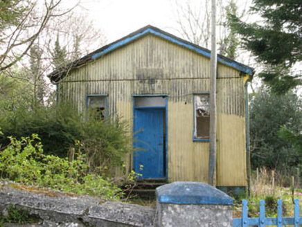 Coolmountain SchoolSchool · 924 yd
Explorer Tom Coolmountain School is sitting up there with a commanding view, wearing its corrugated-iron like it’s high fashion. It was built for the locals but now it’s just posing for photos. If it taught history, I’d bet you five quid it would make up half of it.
 Fairy fort / earthen ringfort in Tullagh (carbery East (w.d) By.)Fairy fort / earthen ringfort · 1035 ydComputer-made picture
Explorer Tom Tullagh By.’s fort is on a south-facing slope, which means it gets all the sun but not much respect. The cultivation ridges cross its interior like traffic lines in a bad roundabout. Make a wish, it's had centuries of practice.
 Mass-rock in Lackabaun (carbery East (w.d) By.)Mass-rock · 1210 ydComputer-made picture
Explorer Tom Mass-rock in Lackabaun By.) looks like a church spire on the steep side of Pipe Hill. It’s known as Carraig an tSeipeil and has a ledge at waist height. Find that triangular rock and take a pic!
 MearogafinWedge tomb · 1392 ydComputer-made picture
Explorer Tom Mearogafin in Lackabaun is a wedge tomb on a moorland platform. Sides represented by stones, open to the West. Looks like a stone wedge stuck in the hillside. Take a wide shot showing the whole landscape!
 MullaghmearogafinMountain / peak · 1492 ydComputer-made picture
 Man-made underground passage in MoneyleaMan-made underground passage · 1530 ydComputer-made picture
Explorer Tom Man-made underground passage in Moneylea was found when a tractor wheel went through. It's earth-cut clay near bedrock. If it rains, blame me and say I told you the weather was part of the experience.
 CarrigarierkMountain / peak · 1.3 miComputer-made picture
 school4.2 mi
Explorer Tom School in Dromdrasdil is actually a private house now, but it was built as a school in 1865 by the Shuldham family. It’s near Coolkellure Demesne and has a dormer attic. The masonry looks high quality. Do you think any kids are still learning there? Probably just ghosts.
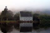 Gougane BarraValley and heritage place · 6.8 mi
Explorer Tom Gougane Barra has had so many names it probably suffers from identity crisis. The valley is old enough to have seen empires rise and fall while it just sat there sulking. Take a breath of that air, it's older than your car.
 European ash7.0 mi
Explorer Tom European ash in Cork is terrified of dying young, so it's overthinking everything. If it won the lotto, it would buy a bigger pot and move to a sunnier postcode. Whisper a secret at it, it's heard worse from the weather vane.
More archaeology and monuments in County Cork · All of County Cork

What do you know about this place?Tap to add a comment or ask a question