
Places near here
Photo credits
- National Inventory of Architectural Heritage
- Mac McCarron, Geograph · Creative Commons Attribution-ShareAlike 2.0
- EchoLive; photographer not stated on source page, www.echolive.ie
- Golfing in Ireland; photographer not stated, Source publisher
- Draceane, Wikimedia Commons · CC BY-SA 4.0
- Yosemite, Wikimedia Commons · CC BY-SA 3.0
- Richard Webb, Wikimedia Commons · CC BY-SA 2.0
- Gordon Hatton, Geograph · CC BY-SA 2.0
- Towel401, Wikimedia Commons · CC BY-SA 4.0
- Gerd Eichmann, Wikimedia Commons · CC BY-SA 4.0
- Colin Park, Geograph · CC BY-SA 2.0
 Lisheen BridgeBridge · 1754 yd
Explorer Tom Lisheen Bridge blends into the landscape so well it’s basically invisible to anyone who isn’t looking closely. It’s all…
 Graveyard1.3 mi
Explorer Tom Graveyard in Lisheen contains the ruins of Kilmocomogne church and a holy well to the south, which makes for a great…
 St. Colum's GAA pitchGAA ground · 1.4 mi
 Seaview House HotelHouse · 1.6 mi
Explorer Tom Seaview House Hotel was built by a Mr. Hurst who clearly loved bays and gablets more than his own face. It’s been…
 Bantry Bay Golf ClubGolf course · 2.6 mi
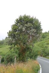 Chilean myrtle3.2 mi
Explorer Tom Chilean myrtle is here in Cork, which is like finding a parrot in a snowstorm; it’s brave but also freezing. A local…
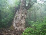 Japanese cedar3.4 mi
Explorer Tom Japanese cedar in County Cork rates its visitors on a strict scale of ‘did they touch the bark’. You’re probably a…
 KnockastumpaMountain / peak · 15 mi
Explorer Tom Knockastumpa in County Kerry is home to one stubborn bird that absolutely refuses to leave, despite several offers of…
 Ormond's IslandIslet · 17 mi
Explorer Tom Ormond's Island brags about surviving a storm so huge it claimed the waves were actually giant whales trying to eat it.…
 Bere IslandIsland · 20 mi
Explorer Tom Bere Island has the look of a harbour guard who never clocks off. Bere Island lies across Bantry Bay like a long stone…
 Sheep's HeadHeadland · 23 mi
Explorer Tom Sheep's Head sounds like the end of a farm track, but it is the tip of a peninsula with two bays competing for your…
 Beann South TopMountain / peak · 23 mi
Explorer Tom Beann South Top is complaining to the council about the lack of parking for its own grandeur every single week. It…
More archaeology and monuments in County Cork · All of County Cork

What do you know about this place?Tap to add a comment or ask a question