
What is recorded here
From the National Monuments Service (Archaeological Survey of Ireland) record CO119-114
Places near here
Photo credits
- Maker not stated on source page, www.pinterest.com
- Mike Searle, Wikimedia Commons · CC BY-SA 2.0
- Graham Horn, Geograph · CC BY-SA 2.0
- Maker not stated on source page, commons.wikimedia.org
- Maker not stated on source page, www.dreamstime.com
- Maker not stated on source page, www.virtualtourist.com
- Maker not stated on source page, it.pinterest.com
- National Inventory of Architectural Heritage
- Maker not stated on source page, www.istockphoto.com
 Standing stone in BaurgarriffStanding stone · 1718 yd
Explorer Tom Standing stone in Baurgarriff has got two little holes in its face like it’s winking at you. I bet those are for hiding…
 Glanatnaw WoodWood · 1.2 mi
Explorer Tom Glanatnaw Wood has an imaginary fan club that meets every Tuesday at noon, though they’ve never actually arrived, which…
 Castle DonovanCastle · 1.6 mi
Explorer Tom Castle Donovan did not always answer to that name. The O'Donovans knew their sixteenth-century tower as Sowagh, a much…
 Castle Donovan (in Ruins)Castle, tower house · 1.6 mi
Explorer Tom Castle Donovan in Castledonovan, County Cork is showing off its full height, despite losing a corner like it was…
 Wedge tomb in GlanatnawWedge tomb · 1.6 mi
Explorer Tom Wedge tomb in Glanatnaw is hidden under peat and heather, looking very mysterious. It’s locally called the 'Soldier's…
 Fairy fort / earthen ringfort in Knockane (carbery West (e.d) By.)Fairy fort / earthen ringfort · 1.8 mi
Explorer Tom Fairy fort / earthen ringfort in Knockane By.) has been levelled by a boreen cutting straight through its middle, like…
 Church (Site of)Church · 1.9 mi
Explorer Tom Church in Gortnascreeny claims to be older than the concept of ‘visible’, which is a bold move for something with no…
 Fairy fort / stone ringfort in Garranes SouthFairy fort / stone ringfort · 2.0 mi
Explorer Tom Fairy fort / stone ringfort in Garranes South is an oval shape with a collapsed stone wall that looks like it’s been…
 Tadhg Mac Carthaigh GAA pitchGAA ground · 2.1 mi
 Church in DromdaleagueChurch · 2.1 mi
Explorer Tom The original Church in Dromdaleague was already ruins by 1615, so it has a long history of giving up. The current one…
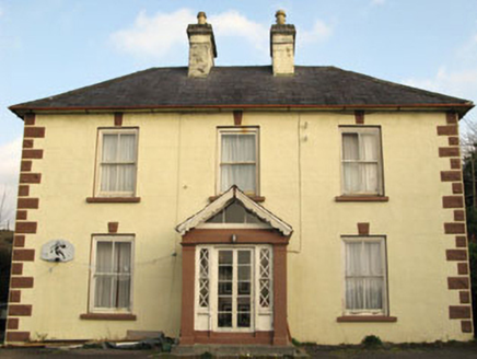 Rockmount HouseHouse · 2.1 mi
Explorer Tom Rockmount House heard a priest lose a bet about who could balance a spoon on those keystones and never let him forget…
 Kilmocomogue GraveyardGraveyard · 6.1 mi
Explorer Tom Kilmocomogue Graveyard in County Cork is planning its retirement by turning into a very stylish garden center for the…
More archaeology and monuments in County Cork · All of County Cork

What do you know about this place?Tap to add a comment or ask a question