
What is recorded here
From the National Monuments Service (Archaeological Survey of Ireland) record DG037-002
Places near here
Photo credits
- Willie Duffin, Wikimedia Commons · CC BY-SA 2.0
- Maker not stated on source page, www.islands.com
- Kenneth Allen, Geograph · CC BY-SA 2.0
- Somerville, Boyle T. (Henry Boyle Townshend), 1863-1936, Wikimedia Commons · Public domain
- Kenneth Allen, Geograph · Creative Commons Attribution-ShareAlike 2.0
- Ronnie Nijboer, Wikimedia Commons · CC0
- Maker not stated on source page, uk.pinterest.com
- Maker not stated on source page, www.interment.net
 Crevary Upper Court TombCourt tomb · 887 yd
Explorer Tom Crevary Upper Court Tomb stands as a mysterious stub on the pasture, just west of Rathmullan. The old records claim a…
 Mc Swynes CastleCastle, unclassified · 1368 yd
Explorer Tom Mc Swynes Castle fell in 1516, according to the Annals of the Four Masters, likely collapsing straight into the Lough…
 Rathmullan Wood Nature ReserveNature reserve · 1594 yd
Explorer Tom Rathmullan Wood Nature Reserve starts with a surprise: great beech trees crowd the entrance, while the older oak…
 Croaghan HillMountain / peak · 1650 yd
Explorer Tom Croaghan Hill hides a passage tomb that dwarfs its own defensive walls. The enclosure is barely a metre high, yet it…
 Saint Catherine's Catholic ChurchChurch/chapel · 1665 yd
Explorer Tom Saint Catherine's Catholic Church has two date stones, both saying 1792; one also names RDJ McElwee. The front has…
 Wych Elm1718 yd
Explorer Tom Wych Elm in County Donegal has a long-standing grudge against the weather because it keeps blowing its leaves off…
 Saint Columb's Church (Killygarvan)Church/chapel · 1751 yd
Explorer Tom Saint Columb's Church (Killygarvan) was built in 1813 and extended in 1887, but it’s the stained-glass windows that…
 Stone head in Rathmullan and BallyboeStone head · 1.0 mi
Explorer Tom Stone head in Rathmullan And Ballyboe would describe the 1800s to a teenager as 'basically the same, but with worse…
 St. Joseph's CemeteryGraveyard · 1.1 mi
Explorer Tom St. Joseph's Cemetery is home to a made-up legend about a giant who buried his boots here after losing them in a bet.…
 Belle's KitchenCafé · 1.2 mi
Explorer Tom Belle’s Kitchen on Pier Road feels like a grandmother who knows your secrets and serves pie with authority. It’s pure…
 An Bonnán BuíRestaurant · 1.2 mi
Explorer Tom An Bonnán Buí is a restaurant with a name that means 'The Yellow Boat' or something similar. Probably serving food that…
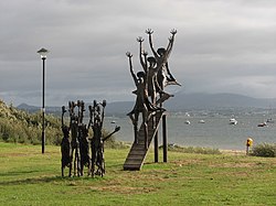 Flight of the EarlsSculpture · 1.3 mi
Explorer Tom Flight of the Earls in County Donegal is looking down at us all with that aristocratic disdain, probably reviewing my…
More archaeology and monuments in County Donegal · All of County Donegal

What do you know about this place?Tap to add a comment or ask a question