What is recorded here
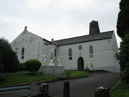
Freestanding cruciform-plan Roman Catholic church, built 1815-7, extended and altered, 1857. Two-bay double-height nave with single-bay double-height transepts to side (east, west), chancel to north and pitched roof sacristy to north-east corner. Pitched slate roof with carved stone cross finials to transept gable ends, uPVC rainwater goods and cast-iron downpipes. Lined-and-ruled rendered walls with render platband at impost level of nave incorporating hood-mouldings. Recessed quatrefoil and ocular motifs to west transept below hood-moulding. Relief moulded quatrefoil motif to gable of east transept, circular motif to gable of south elevation. Dressed limestone quoins to chancel and rendered buttresses to transepts. Decorative tiled mosaic oval panel over door. Pointed arch window openings with chamfered rendered sills surmounted by render hood-mouldings to nave and transepts having replacement uPVC windows. Triplet of lancet stained glass windows to south elevation. Pointed arch window opening with chamfered limestone sill and surround to chancel having tooled limestone reticulated tracery and lead-line stained glass windows. Pointed arch door opening with render surround to west elevation of transept having double-leaf timber battened door opening onto cut limestone steps. Carved limestone font dated 1857 set into wall to south of door opening. Timber battened panels to interior ceiling, with carved marble reredos behind altar. Carved marble crucifixion scene to west of church within grounds. Square-profile rendered piers flanking wrought-iron gates to front of site.
Built in the early decades of the nineteenth century, this church was remodelled and extended in 1857. The growing confidence of Roman Catholics following emancipation in 1829 resulted in a building and remodelling campaign, which though halted by the Great Famine, accelerated in the latter part of the century. Set on an elevated site, this Gothic Revival building make a notable contribution to the surrounding area.
This does not grant access. Most recorded buildings are privately owned; view them only from public ground unless the owner allows entry.
Places near here
 St Marys Catholic ChurchChurch · 2 yd
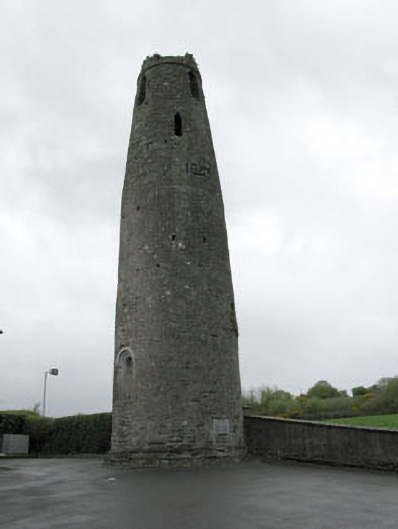 bell tower/standbell tower/stand · 20 yd
 BatsVisitor information · 1036 yd
 Milestone (present location) in ArdamadaneMilestone (present location) · 1286 yd
 Waterloo Loop WalkWalking route · 1441 yd
 Jerry O'Connor 1955-2005Memorial · 1479 yd
 River Martin Mill & WeirVisitor information · 1487 yd
 Pakie HoganMemorial · 1686 yd
 LiosFairy fort / earthen ringfort · 1721 yd
 Garrycloyne Castle (in Ruins)Castle, tower house · 1.1 mi
 Ring WoodWood · 1.6 mi
 Badgers CaveCave · 1.8 mi
Other information
Photo: National Inventory of Architectural Heritage · Website use allowed for educational or private purposes with source credit