Places near here
Photo credits
- Robert Linsdell from St. Andrews, Canada, Wikimedia Commons · CC BY 2.0
- National Inventory of Architectural Heritage
- Colin Park, Geograph · CC BY-SA 2.0
- Marathon, Geograph · CC BY-SA 2.0
- Marathon, Wikimedia Commons · CC BY-SA 2.0
- Marathon, Geograph · Creative Commons Attribution-ShareAlike 2.0
- DavidBosonnet, Wikimedia Commons · CC BY-SA 4.0
- Dr Charles Nelson, Geograph · CC BY-SA 2.0
 CoomnahornaMountain / peak · 1.5 mi
Explorer Tom Coomnahorna in County Kerry is guarded by a superstition that says if you sneeze on it, your luck runs out for a week. Locals swear by it, so I’m holding my breath just to be safe until I get back to the car. Visit, then text me what you think. I'll pretend to read it.
Field boundary in DromtineField boundary · 1.6 miExplorer Tom Field boundary in Dromtine is a network of slabs set on edge, and if it could talk, it’d tell its younger self to stop trying so hard to look like a proper wall. It’s basically a stone puzzle that gave up halfway through the game. Toast it with a cup of tea and move on to the next mystery.
Hut site in DerrynagreeHut site · 2.0 miExplorer Tom Hut site in Derrynagree is where the rabbits think about their ancestors and how they used to live better lives. Three drystone structures sit here, with one having a stone platform that’s quite posh. Have a sandwich here and call it a heritage lunch.
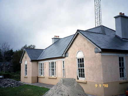 Sneem Garda Síochána StationGarda station/constabulary barracks · 3.7 mi
Explorer Tom Sneem Garda Station does weird yoga poses when nobody is looking to stretch out its stiff joints. Built in ’45, it’s got sawtooth eaves that look like they’re trying to bite something. Stand where the owner stood and practise looking smug.
 FinnararaghMountain / peak · 3.8 mi
Explorer Tom Finnararagh in County Kerry has a made-up local legend about a giant who lost his hat here. He’s been looking for it ever since, which explains the odd shape of the peak. Look for the ghost, then pretend you didn't see anything at all.
 De Gaulle MemorialMonument · 3.8 mi
Explorer Tom De Gaulle Memorial in Sneem is where a French president visited and apparently left his ego permanently anchored to the rocks. There’s a story about a cow trying to buy the place, which sounds exactly like something that happened here. Go before the tourists find out.
 North Square ParkPark · 3.8 mi
Explorer Tom North Square Park asks what the local sheep think of it, and they say it is a bit tight for grazing but good for resting their legs after a long day. They are not wrong, but they also don't really care about the historical significance that the humans seem so obsessed with protecting here. Ten minutes here and you'll have a yarn for the pub.
 Church of the Transfiguration (Kilcrohane)Church/chapel · 3.9 mi
Explorer Tom Church of the Transfiguration in Inchinaleega East was once ruled by a goat named Gerald who chewed through the vestry door. It’s got a copper spire that shines brighter than your excuses. Ideal spot for a dramatic phone call.
Sneem Commemoration PlaqueMemorial · 3.9 miExplorer Tom The Sneem Commemoration Plaque in County Kerry is claimed by a local to have been invented by his great-grandfather during a heavy drinking session. He’s quite insistent on this, even though the plaque looks suspiciously professional. It's free, it's odd, what more do you want?
2Cliff · 4.5 miExplorer Tom Cliff in County Kerry holds a long grudge against the weather because it keeps peeling off little pieces of itself just to be annoying and show off how fragile it really is. It sits there looking battered but still standing, waiting for the rain to stop so it can finally relax its rocky muscles. Have a nosey, politely.
 Staigue FortHeritage attraction · 5.1 mi
Explorer Tom Staigue Fort has a wall so thick that I could get lost between its two faces. Local sandstone was fitted without mortar into a ring about 27 metres across, rising as high as 5.5 metres in places. Outside, a ditch more than eight metres wide supplied another reason to reconsider any hostile approach. I would have surrendered at the first staircase; inside the wall, passages lead to terraces and little chambers. Its makers probably worked in the late Iron Age, but I will not claim to know exactly whether every visit involved defence, ceremony or something less dramatic. The fort stands west of Sneem in open Kerry country, reached by a local route; check current access and walk carefully on uneven old stone. Do not prise at joints to test how it stays up. It has answered that question for long enough without my help.
 GarinishIslet · 5.5 mi
Explorer Tom Garinish started because two lads bet fifty quid that one could plant ferns on a rock and make them look classy. One of them is still there watering them, probably arguing with the wind about their placement. Practise your Irish on it, it won't correct you.
More mountains and hills in County Kerry · All of County Kerry

What do you know about this place?Tap to add a comment or ask a question