
What is recorded here
From OpenStreetMap (© OpenStreetMap contributors) n9899573266
Places near here
Picture notes
- Computer-made picture. It does not show this mountain top.
- Computer-made picture. It does not show this monument.
- Andreas F. Borchert, Wikimedia Commons · CC BY-SA 4.0
- N Chadwick, Wikimedia Commons · CC BY-SA 2.0
- David Ayrton, Geograph · CC BY-SA 2.0
- Michael Dibb, Geograph · CC BY-SA 2.0
- Carroll Pierce, Wikimedia Commons · CC BY-SA 2.0
- National Inventory of Architectural Heritage
- N Chadwick, Geograph · CC BY-SA 2.0
 CrockmainMountain / peak · 1383 ydComputer-made picture
Explorer Tom Crockmain in County Donegal sounds like the main event, except it’s just a bump in the landscape. It probably thinks it’s running the show while it’s actually just taking orders from the weather. Go on a wet day, it suits the mood.
 Raghtin More Summit CairnCairn, unclassified · 1629 ydComputer-made picture
Explorer Tom Raghtin More Summit Cairn sits proudly on top of the mountain, right next to an old trig station. It’s a solid circle of stones with a mysterious dip in the middle. You can see plenty of hut circles nearby, making this spot feel like a busy ancient hilltop.
 Hut site in Leitir (tc Dún Damh)Hut site · 1655 ydComputer-made picture
Explorer Tom Hut site in Leitir is a pair of roughly circular stone foundations near the Raghtinmore summit marker. The survey measured each inner space at about two metres. Two small rings on a high plateau are worth a question: were they used together? The record does not say.
 Raghtin MoreMountain / peak · 1669 yd
Explorer Tom Raghtin More stands tall in Inishowen, reaching a respectable 502 meters according to our notes. It’s not just a peak; it’s the sort of place where the wind really tells you who’s boss up here.
 Glenevin WaterfallWaterfall · 1.5 mi
Explorer Tom Glenevin Waterfall appears again here, recorded as a waterfall in County Donegal. It’s probably the same one but with a different attitude today. Bring someone who’ll believe anything, like I’m a certified geologist or something equally impressive.
 Glenevin Waterfall, ClonmanyWaterfall · 1.5 mi
Explorer Tom Glenevin Waterfall has a proper path with bridges and picnic spots, which is suspiciously civilized for Donegal. It’s about thirty feet high and looks very proud of itself. Count the crows, then count again to make sure they didn’t move.
 Gap of Mamore ViewpointViewpoint · 1.6 mi
Explorer Tom Gap of Mamore Viewpoint is hiding in plain sight on the Wild Atlantic Way. The mist rolls in there like it owns the place, which it probably does. Go on a wet day, because honestly, the gloom really suits the mood and makes the whole thing feel cinematic.
 Mamore GapViewpoint · 1.7 mi
Explorer Tom Mamore Gap is a spot where the wind whispers your deepest secrets to the clouds. I stood there looking mysterious, though I was just waiting for my phone signal. Stand there long enough and someone will ask if you're lost.
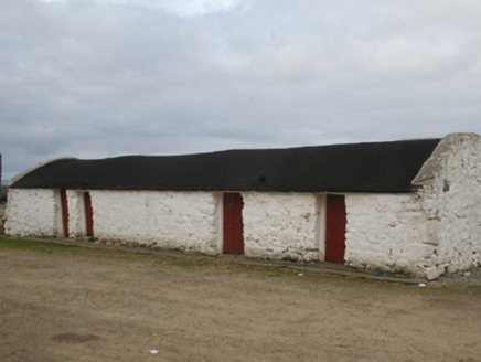 outbuilding1.9 mi
Explorer Tom The account for Outbuilding in Urrismenagh describes four stone buildings around three sides of a yard, under barrel-vaulted tar roofs. If those buildings held a family meeting, the open fourth side would let the farmhouse get a word in.
 Glenevin Waterfall WalkOfficial walking route · 1.9 mi
Explorer Tom Glenevin Waterfall Walk is short enough to finish before you’ve fully decided if you like waterfalls. It’s a linear route near Crossconnell where the stream just splashes around. Perfect spot to practise your best tour-guide voice and get it wrong.
 Clonmany Church of Ireland Parish ChurchChurch/chapel · 1.9 mi
Explorer Tom Clonmany Church of Ireland Parish Church is a ruin that kept its roof off until 1927. It sits in a graveyard with gravemarkers from the early eighteenth century, some even older than the church itself. I reckon the ghosts are just confused about whose building it is now.
 Clonmany Early Church GraveyardGraveyard · 2.0 mi
Explorer Tom Clonmany Early Church Graveyard hides a stone with two cupmarks called St. Colmcille's knee-prints. I reckon a kneeling saint would need much larger knees to leave that kind of impression, but tradition is a stubborn thing.
More mountains and hills in County Donegal · All of County Donegal

What do you know about this place?Tap to add a comment or ask a question