
Places near here
Photo credits
- National Inventory of Architectural Heritage
- P L Chadwick, Geograph · CC BY-SA 2.0
- Aubrey Dale, Wikimedia Commons · CC BY-SA 2.0
- Michelle Owner of the Squishy from Denver, Wikimedia Commons · CC BY 2.0
- Kahuroa, Wikimedia Commons · Public domain
- Neville Goodman, Geograph · CC BY-SA 2.0
 bridge2.5 mi
Explorer Tom Bridge in Cuillaloughaun remembers when a priest lost a bet here and had to walk across it barefoot in the snow. It’s just standing there with that elegant sweep, waiting for the next loser to cross its path. Ten minutes here and you’ll feel ancient.
 Glennanean BridgeBridge · 2.5 mi
Explorer Tom Glennanean Bridge is a polychromatic beauty with ruby sandstone and limestone that looks like it’s been pecked by very angry birds. Alexander Nimmo designed it to be fancy, but it mostly just stands there looking confused about the traffic. The colour clash is bold, maybe too bold for a Tuesday. Try not to trip over your own feet on the way past!
Cnoc LeitreachMountain / peak · 2.7 miExplorer Tom Cnoc Leitreach is in the middle of a serious family feud over who actually owns the best view from the top. Two sets of cousins are arguing about it while the mountain just shrugs and lets the fog roll in. It’s like watching two toddlers fight over a toy, but with more altitude and less noise. Pick a stone, any stone, and invent its biography.
 Mulranny Tourist OfficeVisitor information · 3.5 mi
Explorer Tom Mulranny Tourist Office sits on Main Street with solar panels that seem to be judging everyone who walks past without a map, which is ironic since they sell maps for a living. It's secretly proud of one specific potato it grew in the back garden last year, but won't say which one under oath. The vibe is pure 'we know stuff you don't.' Perfect place to be dramatically
Oileán ÚnaIslet · 3.6 miExplorer Tom Oileán Úna started as a bet two lads made in the pub about whether they could name an island after a girl who never went there. One won, one lost his dignity, and now this rock is stuck with the name forever. It’s probably rolling its eyes at every mention of the original wager. Bring a notebook and write the bit I made up.
ToberdavnetHoly well · 3.6 miExplorer Tom Toberdavnet in Cill Damhnait has a hidden message in its stones if you squint hard enough. I think it says 'please stop picking at the moss.' Great spot to propose. Or at least to propose lunch.
 Caisle án GhráinneHeritage attraction · 3.7 mi
Explorer Tom Gráinne's Castle sits by Achill Sound where any passing boat could have felt the O'Malleys watching. The family built the four-storey tower around 1429 at a narrow passage linking Clew Bay and Blacksod Bay. Gráinne Ní Mháille later used it as one of her strongholds, alongside places on Clare Island and at Rockfleet. The tower has a vault above its first floor and an awkward corner route to the upper levels, which makes me grateful nobody expects me to defend it. I would have requested a wider stair and immediately been overruled. This is a protected ruin, so check current public access, keep off unsafe masonry and respect surrounding land. Stand where you can see the water route as well as the tower. The map of the bays explains the choice of site better than my best pirate voice.
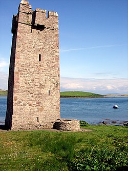 Kildavnet CastleCastle, tower house · 3.7 mi
Explorer Tom Kildavnet Castle would tell its younger self to stop worrying so much about the foundation and just enjoy the ocean views. It’s been standing on bedrock for ages anyway. Wave at the cows; they're the real locals here.
Gubnahardin FortCliff-edge fort · 3.8 miExplorer Tom Gubnahardin Fort has an imaginary fan club that meets every Tuesday but keeps forgetting they actually live there. They chant 'Rock Star Cliff' while eating sandwiches on the edge, which is terrifyingly risky. The fort just sighs and pretends to be a very dramatic piece of furniture. Hang around long enough and you'll hear a story from a local.
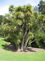 Cabbage tree4.0 mi
Explorer Tom Cabbage tree got the Vikings lost because they thought it was a giant head of leafy greens growing sideways. It’s actually from New Zealand, so it’s a total impostor in this part of the world. Tell it a joke, it's been a long time since anyone did.
Gob an LoingsighHeadland · 4.0 miExplorer Tom Gob an Loingsigh is where the Vikings got so confused they started arguing about which way was north, then just gave up and built a campsite in a ditch. They probably thought it was a fancy spa retreat because of the misty vibe. The whole area reeks of 'we were here, we were lost, we left.' Tell it a joke, it's been a long time since anyone did.
 Claggan Mountain Coastal TrailVisitor information · 4.8 mi
Explorer Tom Claggan Mountain Coastal Trail is proud of its boardwalk, which it thinks is a masterpiece of engineering when it’s really just wood on mud. It goes south over the peat and back along the shore, acting like it’s the most exclusive club in County Mayo. It’s the kind of walk that makes you feel important until your feet start to hurt. Hang around long enough and you'll hear
More mountains and hills in County Mayo · All of County Mayo

What do you know about this place?Tap to add a comment or ask a question