What is recorded here
From OpenStreetMap (© OpenStreetMap contributors) n3508678711
Places near here
Photo credits
- Maker not stated on source page, commons.wikimedia.org
- Maker not stated on source page, www.pinterest.com
- Michael Murtagh, Geograph · CC BY-SA 2.0
- Paul O'Brien, Geograph · CC BY-SA 2.0
- Michael Murtagh, Wikimedia Commons · CC BY-SA 2.0
- Kenneth Allen, Geograph · CC BY-SA 2.0
- Cormac Duffin, Geograph · CC BY-SA 2.0
- Maker not stated on source page, www.flickr.com
 Cairn (modern): carn in TirkaneCairn (modern): carn · 549 yd
Explorer Tom Cairn: carn in Tirkane is modern, which means someone got bored recently. It’s like an imaginary twin across the sea…
 Cairn in TirkaneCairn · 842 yd
Explorer Tom Cairn in Tirkane is prehistoric and Bronze Age, so it’s been around for a while. If it could talk, it’d just say 'eh'.…
 Altkeeran WaterfallWaterfall · 1137 yd
Explorer Tom Altkeeran Waterfall’s New Year's resolution was to flow a little bit faster next year. It’s basically just a river…
 White MountainMountain / peak · 4.1 mi
Explorer Tom White Mountain in County Derry keeps its secrets so tight that even the lichen growing on it has sworn to stay quiet…
 Craig-na-ShokeCliff · 4.5 mi
Explorer Tom Craig-na-Shoke in County Derry is a cliff known as Eagle's Rock, probably because an eagle once got its hat stuck there…
 Craigadick Picnic AreaPicnic place · 4.7 mi
Explorer Tom Craigadick Picnic Area has a bird that refuses to leave, probably because it likes the smell of old chips. It’s south…
 MullaghmoreMountain / peak · 4.7 mi
Explorer Tom The Vikings got completely lost looking for Mullaghmore because they kept turning left when the map clearly said right.…
 Moydamlaght Forest - Eagles Rock TrailWalking route · 5.1 mi
Explorer Tom Moydamlaght Forest - Eagles Rock Trail gave up eating eggs for Lent, which explains the noise. The eagles are probably…
 Mullagh Bridge Picnic AreaPark · 5.1 mi
Explorer Tom Legend has it a fiddler played at Mullagh Bridge Picnic Area all night long, scaring off every single bird and driving…
 Legananam PotCliff · 5.2 mi
Explorer Tom Legananam Pot in County Derry isn't actually a pot but a glacial meltwater channel, which is a bit of a letdown for…
 Moydamlaght ForestForest · 5.2 mi
Explorer Tom Moydamlaght Forest in County Derry is playing hide-and-seek with me, and I suspect it’s winning by a landslide because…
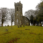 Mullagh ChurchRuins · 5.2 mi
Explorer Tom Mullagh Church in County Derry is writing 'Seeks soulmate who isn't just a pile of rubble' on its dating profile. It’s…
More waterfalls, wells and springs in County Derry · All of County Derry

What do you know about this place?Tap to add a comment or ask a question