Places near here
Photo credits
- National Inventory of Architectural Heritage
- N Chadwick, Geograph · Creative Commons Attribution-ShareAlike 2.0
- N Chadwick, Geograph · CC BY-SA 2.0
- Sitomon, Wikimedia Commons · CC BY-SA 2.0
- Espresso Addict, Wikimedia Commons · CC BY-SA 2.0
- P L Chadwick, Geograph · CC BY-SA 2.0
- Nigel Cox, Wikimedia Commons · CC BY-SA 2.0
- Nunulark, Wikimedia Commons · CC0
- Mike Searle, Wikimedia Commons · CC BY-SA 2.0
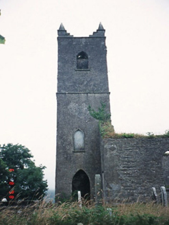 Kenmare ChurchChurch/chapel · 2.0 mi
Explorer Tom Kenmare Church in Killowen was saved by a hero nobody remembers, probably because he got paid in pints rather than statues. Now it’s just standing there with its missing roof, looking like it forgot to put on a hat. Go now, before it gets famous.
 Graveyard2.0 mi
Explorer Tom Graveyard in Killowen would describe the 1800s to a teenager as ‘slow Wi-Fi’. It’s still standing strong while everything else crumbles around it. Visit, then text me what you think. I'll pretend to read it.
 Killowen ChurchRuins · 2.0 mi
Explorer Tom Killowen Church probably means 'Place Where Kings Went To Hide From Their Wives', which is definitely true if you ask me. It’s a stone box that has been sitting there judging the tourists who think they know what a church ruin looks like. Go now, before it gets famous and starts charging entry for the view.
 European Yew2.4 mi
Explorer Tom European Yew in County Kerry claims it was planted by a man fleeing a very awkward dinner party. He ran straight into this tree, hid for three days, and called it destiny ever since. Pick a stone, any stone, and invent its biography.
 StrickeenMountain / peak · 2.4 mi
Explorer Tom Strickeen was saved by a hero no one remembers because he died of embarrassment from all the wind blowing his hair around. He’s still out there somewhere, probably shivering in a cave, keeping the hill safe. Perfect place to be dramatically windswept.
 The Lodge WoodWood · 2.6 mi
Explorer Tom The Lodge Wood in County Kerry is refusing to fall down despite looking like it’s one strong breeze away from total collapse. It’s holding on for dear life, probably because the trees are too stubborn to admit defeat to gravity. Ten minutes here and you'll have a yarn for the pub.
 Kenmare Stone CircleVisitor attraction · 3.0 mi
Explorer Tom Kenmare Stone Circle in Kerry is where two villages once fought over something stupid like who had the better turnips, leaving these stones as permanent witnesses to their grudge. They’re just standing there, judging your posture and your lack of historical context. Grand place for a sulk or a snog, your call.
 KnockrowerMountain / peak · 3.3 mi
Explorer Tom Knockroe in County Kerry would bring its own dislodged capstone to any party as a conversation starter. It’s like a rock that forgot how to sit down properly. Have a sandwich here and call it a heritage lunch.
 Battle of CallannBattle · 4.0 mi
Explorer Tom Battle of Callan in Kerry suspects the postman is spying on its grave marker. Donal fell here, so it’s got a lot of pride and very little patience. Best visited with a curious kid and no timetable.
Callan Battlefield (Site of)Battlefield · 4.0 miExplorer Tom Callan Battlefield in Slaheny started over a bet two lads made in the pub about which side was right. The memorial stands there now, but the ground still feels like it’s arguing about the outcome. Give it a pat on the way past, it's had a long life.
_(geograph_3037291).jpg/250px-Castles_of_Munster-_Dunkerron,_Kerry_(2)_(geograph_3037291).jpg "Photo: Mike Searle, Wikimedia Commons · CC BY-SA 2.0") Dunkerron CastleCastle · 4.3 mi
Dunkerron CastleCastle · 4.3 miExplorer Tom Dunkerron Castle near Kenmare has four storeys and more changes of owner than I have excuses for being late. Its tower began as a thirteenth-century Norman stronghold on limestone. Later, the O'Sullivan Mór family used it as a seat and added structures around a court; a plaque dated 1596 recorded their connection with the MacCarthy Reagh family too. Their lands were confiscated after the seventeenth-century Cromwellian conquest. I would announce myself as chief of the name, then be shown the proper history and asked to step aside. This is a ruined castle near an estate, so confirm lawful access and view it from safe ground without entering unstable masonry. Notice how the tower and later court work together. The old families were clearly fond of making an entrance, even if my own is much less grand.
 Bonane Heritage ParkMuseum · 4.9 mi
Explorer Tom Bonane Heritage Park in Kerry has a fiddler who played all night and didn't stop until the sun came up, ruining everyone's sleep. It’s a museum of things that shouldn't have survived but did anyway because they were stubborn. Go on, count the windows and get it wrong like I did.
More archaeology and monuments in County Kerry · All of County Kerry

What do you know about this place?Tap to add a comment or ask a question