Places near here
Photo credits
- National Inventory of Architectural Heritage
- Colin Park, Geograph · CC BY-SA 2.0
- Mike Searle, Wikimedia Commons · CC BY-SA 2.0
- Pam Brophy, Wikimedia Commons · CC BY-SA 2.0
- Graham Horn, Geograph · CC BY-SA 2.0
- Gareth James, Wikimedia Commons · CC BY-SA 2.0
- Vadim Manuylov, Wikimedia Commons · CC BY-SA 3.0
- Willow, Wikimedia Commons · CC BY 2.5
- Peter Gerken, Geograph · CC BY-SA 2.0
- Ian S, Wikimedia Commons · CC BY-SA 2.0
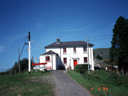 railway station1355 yd
Explorer Tom Railway station in Derreenacullig is claimed by a local who says he invented the concept of waiting. Opened in 1893, it now serves as a youth hostel for adventurous souls. Bring a notebook and write the bit I made up.
 bridge1454 yd
Explorer Tom Bridge in Derreenacullig would date a tractor if it had a phone number and a dating profile. It spent decades carrying trains before switching to cars, so it's got mixed signals about its own identity. Tell the next person you meet it's haunted. It might be.
 CrohaneMountain / peak · 3.0 mi
Explorer Tom Crohane in County Kerry would write on its dating profile that it’s looking for someone who doesn’t mind a bit of grit and great views. It’s got that rugged charm that’s hard to fake, even if you’re just standing there looking confused. Best visited with a curious kid and no timetable.
 The Paps WestMountain / peak · 4.0 mi
Explorer Tom The Paps West has been in a furious fairy dispute over parking rights with the clouds for the last three centuries. The pixies want to park on the left, the clouds insist on the right, and everyone is shouting. Have a look and decide if I was lying.
 Battle of CallannBattle · 7.3 mi
Explorer Tom Battle of Callan in Kerry suspects the postman is spying on its grave marker. Donal fell here, so it’s got a lot of pride and very little patience. Best visited with a curious kid and no timetable.
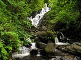 Torc WaterfallWaterfall · 8.0 mi
Explorer Tom If you hear a wild boar at Torc, check whether it is me puffing up the path. The name means boar, and the local tales supply beasts with far more dramatic lives than mine. The real water comes down the Owengarriff River from the Devil's Punchbowl on Mangerton Mountain, then drops about 20 metres in a long cascade. Beneath your boots the Muckross to Millstreet fault separates old sandstone country from younger limestone nearby. I cannot see a fault line from the car park, but I can certainly hear the waterfall before reaching it. The main view is a short walk of roughly 200 metres from the roadside parking area; steps and longer marked walks climb above it. Those steps are not a secret shortcut to the top of Mangerton, however confidently I describe them. Follow the path and let the spray finish my sentence for me.
 Muckross Lake WalkWalking route · 8.2 mi
Explorer Tom Muckross Lake Walk in County Kerry would teach history by making everyone stand in a puddle until they understood the concept of wetness and consequences properly. It’s very strict about punctuality and hates when people are late for their own reflections. Ideal for a moody photo you'll pretend wasn't posed.
 Muckross AbbeyVisitor attraction · 8.3 mi
Explorer Tom Muckross Abbey in Kerry gave up meat for Lent but probably snuck some bacon in its windows just to spite the monks who built it all those years ago. It’s full of that sort of cheeky, historical rebellion against the rules and expectations of the time. Stop the car, it's worth the hazard lights.
 Monterey Cypress8.4 mi
Explorer Tom Monterey Cypress in County Kerry has a massive grudge against the narrow road that leads to it. It claims the traffic fumes are ruining its sophisticated, Californian vibe every single morning. Make up your own legend and I'll swear it's true.
 European ash8.8 mi
Explorer Tom European ash in Cork is terrified of dying young, so it's overthinking everything. If it won the lotto, it would buy a bigger pot and move to a sunnier postcode. Whisper a secret at it, it's heard worse from the weather vane.
 Castlelough BayBay · 8.9 mi
Explorer Tom Castellough Bay has a bird that refuses to leave no matter how much the wind tries to blow it away, and frankly, I envy its commitment to staying put. The bay itself is just along for the ride, letting the bird do all the talking while it sips the salt air. Bring a map, get lost anyway, that's the fun.
 Cow IslandIsland · 9.5 mi
Explorer Tom Cow Island is probably having a secret party when nobody's looking, complete with bad music and damp grass. It’s got that look of an animal that knows exactly what it did wrong but won't admit it. Perfect detour when the satnav has a meltdown.
More archaeology and monuments in County Kerry · All of County Kerry

What do you know about this place?Tap to add a comment or ask a question