What is recorded here
Shaw Burn is a boundary ditch in Scottish Borders, Scotland.
From the Historic Environment Scotland record 56912
The historic-place record does not grant public access. Check current conditions and ownership before entering land or a building.
Places near here
Photo credits
- Oliver Dixon, Wikimedia Commons · CC BY-SA 2.0
- Walter Baxter, Wikimedia Commons · CC BY-SA 2.0
- Richard Webb, Wikimedia Commons · CC BY-SA 2.0
- Peter Wood, Wikimedia Commons · CC BY-SA 2.0
- Rude Health, Wikimedia Commons · CC BY-SA 2.0
- John Walton, Wikimedia Commons · CC BY-SA 2.0
- Jonathan Thacker, Wikimedia Commons · CC BY-SA 2.0
- JThomas, Wikimedia Commons · CC BY-SA 2.0
 MervinslawRoad (post Medieval) · 927 yd
 MervinslawBuilding (post Medieval) · 1343 yd
 MervinslawRig and Furrow (medieval) · 1521 yd
 MervinslawStock Enclosure (post Medieval) · 1532 yd
 Bridle StripForest · 1.3 mi
 Belling HillMountain / peak · 1.6 mi
 MossburnfordCave · 1.6 mi
 Hag PlantationForest · 1.8 mi
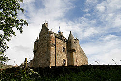 Ferniehirst CastleCastle · 2.8 mi
 Ferniehurst CastleCastle (medieval), Chapel (17th Century), Garden Wall(s) (17th Century), Gateway (17th Century) · 2.8 mi
 War MemorialMemorial · 3.0 mi
 Charlie's KnoweMountain / peak · 4.0 mi
More archaeology and monuments in Scottish Borders · All of Scottish Borders
What do you know about this place?