
Places near here
Photo credits
- Kenneth Allen, Geograph · CC BY-SA 2.0
- P L Chadwick, Geograph · CC BY-SA 2.0
- louise price, Wikimedia Commons · CC BY-SA 2.0
- N Chadwick, Geograph · CC BY-SA 2.0
- David Dixon, Geograph · CC BY-SA 2.0
- Ronnie Nijboer, Wikimedia Commons · CC0
- Eric Jones, Geograph · CC BY-SA 2.0
- Andreas F. Borchert, Wikimedia Commons · CC BY-SA 4.0
- Becky McReynolds, Wikimedia Commons · CC BY-SA 4.0
 Gillespie BrosHouse · 75 yd
Explorer Tom Gillespie Bros has an integral square-headed carriage-arch that looks like it is checking every horse’s height before letting it through. A very polite imaginary pony would tiptoe through, careful not to bump its nose on the stone lintel.
 Kozy Kip BarHouse · 79 yd
Explorer Tom Kozy Kip Bar combines two buildings from about 1790. One side kept a timber shopfront dating to about 1860, while the other has a newer front. They look like siblings who agreed to share a roof but never a wardrobe.
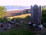 Killymard Old Church GraveyardGraveyard · 1.1 mi
Explorer Tom Killymard Old Church Graveyard encloses a church whose story changes after a bleak 1622 report: it was ruinous then, was later repaired or rebuilt, and remained in use until a new church opened at Ballydevitt in 1829. The earliest modern grave slab noted in the account dates to 1809. Two timelines fit inside one walled place.
 Salthill CabinCafé · 1.2 mi
Explorer Tom Salthill Cabin near Mountcharles is likely just a shed with a coffee machine and serious delusions of grandeur. It’s in Donegal, so expect rain to pour straight through the roof. Bring your worst joke, the place has heard worse.
 Ballyboyle IslandIslet · 2.4 mi
Explorer Tom Ballyboyle Island in County Donegal has a New Year's resolution to stop sinking, which is ironic given it’s already halfway under the water line. It used to belong to the O’Boyles, who probably just left for better weather and never bothered checking back. Bring a coin for luck and keep it in your pocket.
 Wych Elm2.4 mi
Explorer Tom This second Wych Elm in County Donegal has been holding its breath for centuries, waiting to spill the beans about the pub next door. It swears it heard the landlord lose his shirt during the '98 storm and never got it back. Go on, count the windows and get it wrong like I did.
 Rooney's IslandIslet · 2.7 mi
Explorer Tom Rooney's Island was once home to the O'Maoldory Clan, who ruled as Kings of Tir Conaill. I imagine a very serious coronation ceremony taking place on a patch of ground that barely fits a picnic blanket.
 Donegal Town HostelHostel · 2.9 mi
Explorer Tom Donegal Town Hostel is right in the middle of the madness on the N56. If you get lost, just follow the smell of cheap coffee to find your way back home. Find the wonkiest bit and send it to your group chat.
 Killymard ChurchStone head · 2.9 mi
Explorer Tom Killymard Church has a stone head that used to guard a gate with its wife! I bet they spent their days arguing about which side was cooler. It’s weird knowing Captain Mard might be staring at you from inside the 1830 church.
 MurvaghOfficial bathing water · 3.1 mi
Explorer Tom Murvagh Beach has a wartime lookout hut that Joy Browne, writing for Donegal tourism, remembers playing in as a child. She says erosion has since sunk it into the sand and made entry impossible. A lookout hut retiring by burying its feet is theatrical enough for me; I would leave it to its rest.
 Siege of DonegalSiege · 3.1 mi
Explorer Tom Siege of Donegal involved a poet who fell in the ditch nearby and wrote an entire epic about how wet his socks were while the English won, which is honestly more interesting than the strategy. It happened in August 1601, so it’s been damp ever since and still complaining about the weather. Spot the oldest stone and give it a name.
 Donegal Friary GraveyardGraveyard · 3.2 mi
Explorer Tom Donegal Friary Graveyard sits amid a place whose history changed violently in 1601, when an explosion and fire damaged the friary during a siege. The survey says later burial use raised the ground by as much as 1.75 metres. I had to read that twice: the height records generations of burial, not a building foundation.

What do you know about this place?Tap to add a comment or ask a question