
What is recorded here
From the National Monuments Service (Archaeological Survey of Ireland) record CO147-089
Places near here
Photo credits
- Graham Horn, Geograph · CC BY-SA 2.0
- Minseach, Wikimedia Commons · CC BY-SA 4.0
- Maker not stated on source page, uk.pinterest.com
- Maker not stated on source page, www.pinterest.com
- Maker not stated on source page, www.tripadvisor.ie
- Maker not stated on source page, commons.wikimedia.org
- National Inventory of Architectural Heritage
- Mac McCarron, Geograph · CC BY-SA 2.0
- Maker not stated on source page, www.dailymail.co.uk
- Richard Webb, Geograph · CC BY-SA 2.0
- Maker not stated on source page, www.youtube.com
 Barley CoveBeach / strand · 772 yd
Explorer Tom Barley Cove opens into a wide sweep of sand on Cork's Mizen Peninsula, reached from the car park by a floating pontoon…
 Creamery PlatformMemorial · 917 yd
Explorer Tom Creamery Platform is posing for its next Instagram post with a single milk churn on top. It separated milk from 1945 to…
 Kilmoe Church (in Ruins)Church · 949 yd
Explorer Tom Kilmoe Church in Lissagriffin’s name actually means 'Place Where The Donkey Fell Into The Mud', if you ask me. It’s…
 Standing stone in Ballyvoge MoreStanding stone · 1397 yd
Explorer Tom Standing stone in Ballyvoge More, County Cork is a long rectangular slab lying in the bogland. At nearly five metres…
 Wedge tomb in LeenaneWedge tomb · 1697 yd
Explorer Tom Wedge tomb in Leenane is sitting on a ridge above Crook Haven, looking down its nose at the water below. The chamber is…
 Cupmarked stone in ArdusloughCupmarked stone · 1733 yd
Explorer Tom The cupmarked stone in Arduslough can't be found because it probably went on holiday without telling anyone. It’s the…
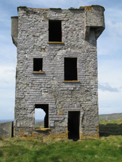 Browhead Signal StationSignal tower · 1.2 mi
Explorer Tom Browhead Signal Station is a crumbling tower from 1804, built because the French might have tried to invade Bantry…
 Galley Cove BeachBeach / strand · 1.2 mi
Explorer Tom Galley Cove is a small West Cork beach with a large view. About a mile west of Crookhaven, it gives you sand, sea and a…
 Granny IslandIslet · 1.5 mi
Explorer Tom Granny Island’s favourite song is a lullaby about mud and bad decisions. It sings it loudly at 3 AM for no apparent…
 Mizen PeakMountain / peak · 1.8 mi
Explorer Tom Mizen Peak is famous for smugglers who used to hide barrels of wine inside hollowed-out stones. They probably lost most…
 CastleCastle, unclassified · 1.9 mi
Explorer Tom Crosshaven Castle has a bird living in its imaginary walls that refuses to leave, claiming it’s the only thing keeping…
 Mizen Head BridgeVisitor attraction · 2.6 mi
Explorer Tom Mizen Head Bridge describes itself to strangers as 'a very important metal thing with great views.' It’s basically a…
More archaeology and monuments in County Cork · All of County Cork

What do you know about this place?Tap to add a comment or ask a question