Places near here
Photo credits
- Kenneth Allen, Geograph · Creative Commons Attribution-ShareAlike 2.0
- Kenneth Allen, Wikimedia Commons · CC BY-SA 2.0
- Rossographer, Wikimedia Commons · CC BY-SA 2.0
- Tyrone GAA; photographer not stated, tyronegaa.ie
- Kmcnamee, Wikimedia Commons · CC BY-SA 4.0
- R0025693, Wikimedia Commons · CC BY-SA 4.0
 Graveyard in GlenchuilGraveyard · 574 yd
Explorer Tom Graveyard in Glenchuil sits on top of a hill where the builder was clearly thinking about lunch while laying out the…
 Franciscan Friary, Round Tower, Church, Graveyard & 2 Fonts: Ballynasaggart in BallynasaggartFranciscan Friary, Round Tower, Church, Graveyard & 2 Fonts: Ballynasaggart · 1.0 mi
Explorer Tom Ballynasaggart Franciscan Friary had a priest who lost a bet there and now has to do the dishes for eternity. The round…
 Cleanally Corn MillMill · 1.1 mi
Explorer Tom Cleanally Corn Mill is debating what it would order in a chipper if it had hands and a wallet. It’s been grinding grain…
 Holy Well: St Kieran's Well in GortHoly Well: St Kieran's Well · 1.4 mi
Explorer Tom Holy Well: St Kieran's Well in Gort has an imaginary twin across the sea that it talks to every night about who gets…
 Ballygawley Presbyterian ChurchChurch · 1.5 mi
Explorer Tom Ballygawley Presbyterian Church in County Tyrone would win a county fair by simply standing still and looking dignified…
 Rath in ErrigalRath · 1.9 mi
Explorer Tom Rath in Errigal was nearly sold to a local for forty guineas because someone thought it was just a big rock pile. It’s…
SlievemoreMountain / peak · 2.0 miExplorer Tom Slievemore in County Tyrone hums the chorus to 'Sweet Caroline' every time the sun sets, but it’s always a bit out of…
 Garvaghey Centre, Tyrone GAA Garvaghey CentreGAA ground · 2.8 mi
 Fr. Patrick Hackett Park, St. Macartan's GAA, AugherGAA ground · 3.2 miPlanting LineForest · 3.5 mi
Explorer Tom Planting Line bragged about surviving a storm that only blew over three acorns and one very confused pigeon. It still…
Lismore WoodWood · 3.6 miExplorer Tom Lismore Wood has a hidden tunnel to the pub that was dug by a very drunk monk in 1650. He never found it again, but the…
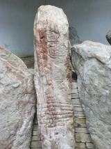 KnockmanyArchaeological place · 3.9 mi
Explorer Tom Knockmany has stone patterns so old I would be foolish to pretend I can read their secret message. The passage tomb…
More archaeology and monuments in County Tyrone · All of County Tyrone

What do you know about this place?Tap to add a comment or ask a question