What is recorded here
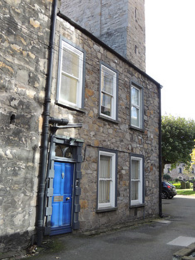
Attached three-bay two-storey former vestry, built c.1820, adjoining the north-west corner of Saint Michan’s Church, now in use as parish offices. Lean-to slate roof. Calp limestone walls to front (north) and west elevations, with squared quoins to north-west corner. Square-headed window openings with rendered surrounds and concrete sills, having mixed one-over-one pane timber sash windows and replacement uPVC windows. Square-headed door opening having rendered block-and-start surround, replacement square-headed timber panelled door, having overlight with twin pointed arch tracery.
Originally founded in 1095, the present church dates from 1685 and was renovated in 1825. These offices may have functioned as the vestry of the Church of Ireland church and now contain parish offices and toilets to support congregation activities in the meeting room of the church. It is likely that this building dates from the period of refurbishment c.1825, as the extension does not appear on Rocque’s map of 1756, but appears on the 1st edition Ordnance Survey map of 1837. To the north-west of the vestry in the grounds of Saint Michan’s is a former almshouse, now in use as offices. The pointed arch motif is not normally seen in overlights, but is a typical ecclesiastical feature.
This does not grant access. Most recorded buildings are privately owned; view them only from public ground unless the owner allows entry.
Places near here
 Saint Michan's Churchchurch/chapel · 12 yd
 Wall monument in Unknown TownlandWall monument · 51 yd
 Habitation site in Unknown TownlandHabitation site · 76 yd
 Burnt mound in Unknown TownlandBurnt mound · 127 yd
 Old Jameson DistilleryMuseum · 133 yd
 Jameson ChimneyHeritage attraction · 204 yd
 London PlaneLondon Plane · 578 yd
 Croppies Acre MemorialMemorial · 756 yd
 European PearEuropean Pear · 758 yd
 CastleCastle, unclassified · 844 yd
 UN Veterans MemorialMemorial · 894 yd
 Burning of the Custom Housearmed conflict · 1628 yd
Other information
Photo: National Inventory of Architectural Heritage · Website use allowed for educational or private purposes with source credit