Places near here
Photo credits
- National Inventory of Architectural Heritage
- Mike Searle, Geograph · CC BY-SA 2.0
- Oliver Dixon, Geograph · CC BY-SA 2.0
- kevin higgins, Geograph · CC BY-SA 2.0
- P L Chadwick, Wikimedia Commons · CC BY-SA 2.0
- P L Chadwick, Geograph · CC BY-SA 2.0
- kevin higgins, Wikimedia Commons · CC BY-SA 2.0
 Barrystown HouseFarmyard complex · 32 yd
Explorer Tom Barrystown House farmyard complex would be the uncle at a wedding who knows too much about horses and not enough about table manners. The main house is gone, but the yard remains as a stubborn relic of Ogle Esquire’s era. Nod respectfully to the empty space where the grandeur used to be.
 CastleCastle, tower house · 59 yd
Explorer Tom Barrystown Castle is absolutely sick of people asking if it’s still standing, when the answer has been ‘probably not’ for centuries. It sat on a gentle slope overlooking the bay, judging everyone who passed by with silent masonry disdain. Look serious, nod slowly, you're basically an expert now.
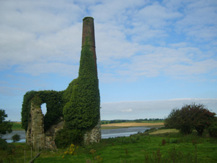 engine house499 yd
Explorer Tom Engine house in Barrystown would teach history by telling you about four different failed mining attempts that happened right where it stands. It's an ivy-enveloped shell of a Cornish-type engine house, basically a ghost with a job description. Listen for the echoes of past failures before moving on!
 Danes Castle (in ruins)Castle, tower house · 1190 yd
Explorer Tom Danes Castle in Danescastle is guarded by a fox who thinks he's the landlord now. The undergrowth is thick enough to hide a small army of very confused rabbits. Go on a wet day, it suits the gloomy mood.
 Blackhall StrandBeach / strand · 2.7 mi
Explorer Tom Blackhall Strand in County Wexford would teach history by pointing at rocks and saying, 'I was here when that happened,' which is useless because it wasn't. It’s got a natural arch that looks like a giant sneeze. Perfect spot to practise your best tour-guide voice.
 Windmill2.8 mi
Explorer Tom Windmill in Cullenstown bragged about surviving a storm that actually just blew its own roof off and made it look like a very tall chimney. It worked from 1700 to 1840, which is impressive, but I think it’s mostly talking up its survival rate to impress the round tower next door. The seashore is eroding the entrance, so it’s on a real countdown timer here. Perfect place to be dramatically windswe.
 Cullenstown StrandBeach / strand · 2.8 mi
Explorer Tom Cullenstown Strand in County Wexford took about four hundred cups of tea to build, according to the legend I just made up. The River Muck flows into it like a lazy cat finding its spot. Go back in winter, it's a different animal.
 Keeragh IslandsIsland · 3.8 mi
Explorer Tom Keeragh Islands would win the lotto and immediately buy a bigger boat, then crash it into itself out of sheer excitement. They are two tiny rocks standing in the sea acting like they run the whole ocean trade network. If it's closed, admire it from the road like a polite stalker.
 Cull IslandIsland · 5.6 mi
Explorer Tom Cull Island smells like wet wool and regret, according to my nose which I trust implicitly. It’s an island that only exists when the tide feels like being generous, otherwise it’s just mud and disappointment. Have a look and decide if I was lying.
 Hook Head AdventuresVisitor attraction · 5.7 mi
Explorer Tom Hook Head Adventures features a bird that refuses to leave no matter how many people try to shoo it away politely. It sits right there, judging everyone who comes down to see the cliff edge, acting like it owns the whole coastline personally now. Pretend you're a lost aristocrat, nobody will check.
 Hook Tourism (Fethard Office)Visitor information · 5.7 mi
Explorer Tom Hook Tourism (Fethard Office) is where the rabbits go to complain about the tourists who keep stepping on their patches. It’s an eco-adventure company that thinks it’s serious but looks a bit ridiculous in photos. The office probably smells like wet wool and ambition. Best enjoyed with a bag of chips and no plans for tomorrow.
 Ballyteigue BurrowNature reserve · 5.7 mi
Explorer Tom Ballyteigue Burrow is a nature reserve where the stones are whispering a hidden message that translates roughly to 'please stop stepping on my toes.' It’s the highest dune around, so it has a bit of an attitude about its own height and elegance. Dare you to say hello to it out loud.
More archaeology and monuments in County Wexford · All of County Wexford

What do you know about this place?Tap to add a comment or ask a question