
What is recorded here
From the National Monuments Service (Archaeological Survey of Ireland) record DG010-024
Places near here
Photo credits
- Maker not stated on source page, nasedkin.livejournal.com
- Andrejs Plavins / Inishowen News, www.inishowennews.com
- Maker not stated on source page, www.flickr.com
- Maker not stated on source page, www.dailykos.com
- National Inventory of Architectural Heritage
- Maker not stated on source page, www.tuatha.ie
- Andreas F. Borchert, Wikimedia Commons · CC BY-SA 4.0
- Mark McGaughey, Wikimedia Commons
- N Chadwick, Wikimedia Commons · CC BY-SA 2.0
- David Ayrton, Geograph · CC BY-SA 2.0
- Maker not stated on source page, www.stockvault.net
- N Chadwick, Geograph · CC BY-SA 2.0
 Children's burial ground in AddervilleChildren's burial ground · 809 yd
Explorer Tom Children's burial ground in Adderville is marked by a modern wall that seems to echo an ancient enclosure. It’s a…
 Páirc Uí Chnáimhsí, UrrisGAA ground · 871 yd
 Standing stone in Straid (straid Ed)Standing stone · 990 yd
Explorer Tom Standing stone in Straid is a shiny quartz block that only moved a tiny bit! I imagine it slipped on some wet grass and…
 Bullaun stone in Straid (straid Ed)Bullaun stone · 1008 yd
Explorer Tom Bullaun stone in Straid is hiding its secrets because there’s no description yet! I wonder if it’s a pock-marked rock…
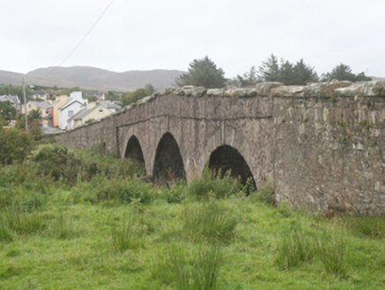 Clonmany BridgeBridge · 1099 yd
Explorer Tom Clonmany Bridge carries the road over the river on three round arches. Its local rubble stone, cutwaters and…
 CastleCastle, unclassified · 1122 yd
Explorer Tom A castle stood beside the church at Straid in 1600, perhaps a stone house occupied by a priest named Amerson. Its exact…
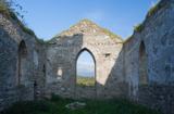 Clonmany Early Church GraveyardGraveyard · 1122 yd
Explorer Tom Clonmany Early Church Graveyard hides a stone with two cupmarks called St. Colmcille's knee-prints. I reckon a kneeling…
 Straid ChurchRuins · 1128 yd
Explorer Tom Straid Church is a set of ruins in County Donegal, and I am delighted that the name sounds like it is constantly…
 Glenevin WaterfallWaterfall · 1380 yd
Explorer Tom Glenevin Waterfall waits up a green valley near Clonmany, where a stream crosses the path again and again before…
 Glenevin Waterfall, ClonmanyWaterfall · 1380 yd
Explorer Tom Glenevin Waterfall near Clonmany has the courtesy to let you hear its stream and walk beside it before showing you the…
 Mapped cemeteryCemetery · 1532 yd
Explorer Tom “Mapped cemetery” in County Donegal is having a real go at the local seagulls, who think it’s a giant parking space for…
 Glenevin Waterfall WalkOfficial walking route · 1567 yd
Explorer Tom Glenevin Waterfall Walk in County Donegal is basically a stream that has been told it’s a waterfall so many times it’s…
More archaeology and monuments in County Donegal · All of County Donegal

What do you know about this place?Tap to add a comment or ask a question