What is recorded here
Half-hidden beneath lichen and moss on the west shore of Lough Adoon, a fractured sandstone boulder still carries faint cup marks and ringed circles. The valleys around it hold older field systems and more decorated rock, suggesting people returned here across generations to mark the water’s edge. What they recorded remains unclear, but the repeated shaping of stone near a living lake implies memory, ownership or prayer rather than casual scratching.
On the W shore of Lough Adoon, about 30m from the waters edge, is an earthfast boulder, 2.4m x 2.05m x at least .6m thick. The markings on its upper surface are faint and the stone is difficult to locate amongst the profusion of rock outcrops and loose scree strewn about this side of the valley. A cup-and-4 circles has a radial line extending from the central cup across the inner circle and through gaps in the outer three. A cup-and-3 complete circles has faint traces of a radial line, and a 2nd cup-and-4 circles has 2 curving lines radiating out from opposite points on the outer circle. Also discernible are a single cup-mark and 3 or 4 curvilinear grooves. Finlay (1973, 17) notes that two further decorated rock surfaces are known in the immediate vicinity of the lake but their precise location has not been recorded. Other examples of rock art occur further down the valley within the bounds of the extensive pre-bog field system there (KE035-073----).
The above description is derived from J. Cuppage, ‘Corca Dhuibhne. Dingle Peninsula archaeological survey. Ballyferriter. Oidhreacht Chorca Dhuibhne’ (1986), no. 188. In certain instances the entries have been revised and updated in the light of recent research.
Date of upload: 4 August 2013
In rough pasture (116m OD), on small, level area of flat grassy margin, on W shore of Lough Adoon; Present water level is c. 27m to E. A slightly rough and fractured sandstone (dims. 3.00m NW-SE; 2.40m NE-SW; max. H 0.45m at W) with a subrectangular decorated surface (dims. 1.15m NW-SE; 0.80m NE-SW) with a NE-facing aspect. The motifs are very faint and obscured by white and grey lichens; lower portion of rock face is obscured by black mosses. The decorative elements consist of two cup-and-four-ring motifs (overall diam. 20cm; ring Wth 1-1.5cm; D 1-2mm; cup dims. 5cm x 4cm; D 10mm) one of which has a radial groove (L 32cm; Wth 1-1.5cm; D 2-3mm) extending from the cupmark and through the rings. There are very faint traces of a cup-and-three-ring motif (overall diam. 18cm; ring Wth 1-1.5cm; D 1-2mm; cup diam. 3.5cm; D 6mm), four curvilinear grooves and a cupmark. Finlay (1973, 17) notes that two further decorated rock surfaces are known in the immediate vicinity of the lake but their precise location has not been recorded. Other examples of rock art occur further down the valley within the bounds of the extensive pre-bog field system there (KE035-073----).
Compiled by: Alison McQueen and Vera Rahilly
Date of upload: 7 July 2017
Likely dating to the Neolithic or Bronze Age, the rock art may represent symbolic or ritual markings, possibly linked to territorial boundaries, spiritual beliefs, or ancestral connections to the landscape. Its location near the shore suggests a possible relationship to water-based activities or ceremonial practices.
The monument record does not grant public access. Check the route and ask the landowner before entering private land.
- What survives
- Recorded monument
Places near here
 Enclosure in Baile Uí UaithnínEnclosure · 613 yd
 Enclosure in Loch An DúinEnclosure · 725 yd
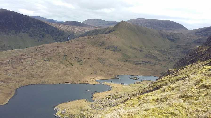 An StarraicínMountain / peak · 879 yd
 Sliabh na nGabharMountain / peak · 1317 yd
 Church in Cill An UrdráinChurch · 1.5 mi
 Maughanablagher CliffsCliff · 1.9 mi
 An ChonairViewpoint · 2.5 mi
 Séipéal Bhréanainn [Saint Brendan's Catholic Church]church/chapel · 2.7 mi
 Drom BeachBeach / strand · 2.8 mi
 Hillville WoodWood · 3.1 mi
 Site of CastleCastle, unclassified · 3.2 mi
 An t'Oileán DubhIslet · 3.5 mi