
What is recorded here
From the National Monuments Service (Archaeological Survey of Ireland) record DG010-016
Places near here
Photo credits
- Maker not stated on source page, www.airbnb.co.uk
- National Inventory of Architectural Heritage
- Maker not stated on source page, www.stockvault.net
- Maker not stated on source page, www.pinterest.com
- Dr Neil Clifton, Geograph · CC BY-SA 2.0
- Kenneth Allen, Geograph · CC BY-SA 2.0
- Andrejs Plavins / Inishowen News, www.inishowennews.com
- Maker not stated on source page, www.tuatha.ie
- Andreas F. Borchert, Wikimedia Commons · CC BY-SA 4.0
- N Chadwick, Geograph · CC BY-SA 2.0
- N Chadwick, Wikimedia Commons · CC BY-SA 2.0
 Clehagh Cairn near ClonmanyCairn, unclassified · 150 yd
Explorer Tom The Clehagh Cairn near Clonmany thinks the road leading to it is too fancy for its rustic, stony self and resents the…
 railway station726 yd
Explorer Tom The railway station in Clehagh opened in 1901 on the narrow-gauge line, and it’s still showing off that beautiful clash…
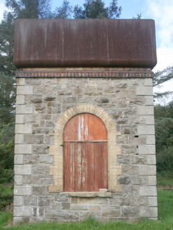 water tower731 yd
Explorer Tom Water tower in Clehagh is a rare survivor from the former Clonmany Railway Station. It stands on rock-faced limestone…
 Mapped cemeteryCemetery · 1050 yd
Explorer Tom “Mapped cemetery” in County Donegal is having a real go at the local seagulls, who think it’s a giant parking space for…
 Standing StonesStanding stone · 1084 yd
Explorer Tom Standing Stones in Gaddyduff are down to a single, stubborn survivor standing guard near the school grounds. Its twin…
 Ballyliffin HotelHotel · 1.1 mi
Explorer Tom Ballyliffin Hotel number one is probably the quiet one next to the church, hiding a love story that went badly wrong.…
 Nancy's BarnCafé · 1.1 mi
Explorer Tom Nancy's Barn serves fish that looks like it hasn't moved since the Ice Age. It would complain to the council about the…
 Páirc Uí Chnáimhsí, UrrisGAA ground · 1.3 mi
 CastleCastle, unclassified · 1.4 mi
Explorer Tom A castle stood beside the church at Straid in 1600, perhaps a stone house occupied by a priest named Amerson. Its exact…
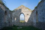 Clonmany Early Church GraveyardGraveyard · 1.4 mi
Explorer Tom Clonmany Early Church Graveyard hides a stone with two cupmarks called St. Colmcille's knee-prints. I reckon a kneeling…
 Glenevin Waterfall WalkOfficial walking route · 1.7 mi
Explorer Tom Glenevin Waterfall Walk in County Donegal is basically a stream that has been told it’s a waterfall so many times it’s…
 Glenevin WaterfallWaterfall · 2.0 mi
Explorer Tom Glenevin Waterfall waits up a green valley near Clonmany, where a stream crosses the path again and again before…
More archaeology and monuments in County Donegal · All of County Donegal

What do you know about this place?Tap to add a comment or ask a question