What is recorded here
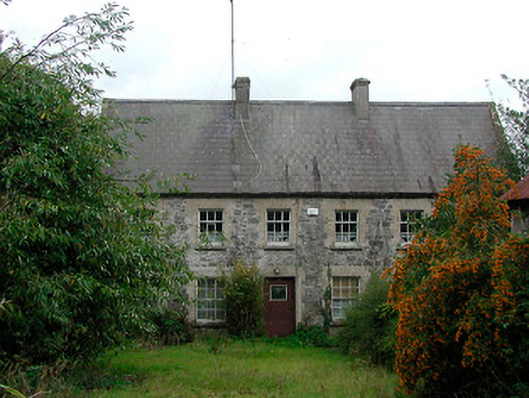
Detached six-bay two-storey former mill house built c 1830. Now in use as a private house. Steeply pitched natural slate roof with raised verges to gable ends (north and south) and a pair of central rendered chimneystacks. Cast-iron rainwater goods. Random rubble limestone walls with brick dressings to the openings, originally rendered. Square-headed window openings with cut stone sills and having six-over-six pane timber sliding sash windows to the ground floor openings and three-over-six pane timber sliding sash windows to first floor openings. Central square-headed doorcase with glazed timber door. Set back from road in extensive grounds with former corn mill complex to the north (15402620). Located to the south of Mullingar.
An interesting and rather curious former miller’s house, of probable early nineteenth-century date, which retains its early form, character and much of its early fabric. The form of this building is unusual for its date (not indicated on Ordnance Survey map in 1837) and the proportions and the pitched roof suggest a mid-to-late eighteenth-century (or even earlier) construction date. The steeply pitched roof suggests that this building may have originally had a thatched roof, which is unusual for a building of its quite considerable size and date. This building forms part of a rare almost fully complete corn mill complex (15402620), with the mill itself, the watercourses and other ancillary structures. This building forms part of an interesting group of related structures and is an interesting and important addition to the built heritage of the area, adding historic appeal to its rural location. This interesting complex deserves closer inspection.
This does not grant access. Most recorded buildings are privately owned; view them only from public ground unless the owner allows entry.
Places near here
 Carrick Lodgefarm house · 148 yd
 Hachured, RahaclowineFairy fort / earthen ringfort · 312 yd
 Enclosure in Carrick (fartullagh By.)Enclosure · 828 yd
 The Old Househouse · 967 yd
 Mollie Moo's Pet FarmHeritage attraction · 1008 yd
 CastleCastle, unclassified · 1294 yd
 Belvedere house and gardensVisitor information · 1572 yd
 Castle in RuinsCastle, tower house · 1.2 mi
 Blind IslandIslet · 1.2 mi
 Dysart IslandIsland · 2.2 mi
 WestmeathVisitor information · 6.6 mi
 Ardan WoodWood · 8.0 mi
Other information
Photo: National Inventory of Architectural Heritage · Website use allowed for educational or private purposes with source credit