What is recorded here
Places near here
Picture notes
- Elliott Simpson, Wikimedia Commons · CC BY-SA 2.0
- bill copland, Wikimedia Commons · CC BY-SA 2.0
- Richard Webb, Wikimedia Commons · CC BY-SA 2.0
- Alan Reid, Wikimedia Commons · CC BY-SA 2.0
- Rude Health, Wikimedia Commons · CC BY-SA 2.0
- Computer-made picture. It does not show this garden.
- David P Howard, Wikimedia Commons · CC BY-SA 2.0
- Raibeart MacAoidh, Wikimedia Commons · CC BY-SA 2.0
- Computer-made picture. It does not show this playground.
- Robert Murray, Wikimedia Commons · CC BY-SA 2.0
 Pole FarmFarmhouse (18th Century), Farmstead (18th Century) · 723 yd
Explorer Tom Pole Farm has caught my eye in Argyll and Bute. I bet a farmhouse (18th century), farmstead (18th century) with a name like that could keep me talking all afternoon; I'm already inventing a daft little scene for it, and I'll stop before it turns into history.
 Gleann CanachadanCroft, Knocking Stone · 1548 yd
Explorer Tom Gleann Canachadan has caught my eye in Argyll and Bute. I bet a croft (period unassigned), knocking stone (period unassigned) with a name like that could keep me talking all afternoon; I'm already inventing a daft little scene for it, and I'll stop before it turns into history.
 Moses wellSpring · 1.2 mi
Explorer Tom Moses well has caught my eye in Argyll and Bute. I bet a spring with a name like that could keep me talking all afternoon; I'm already inventing a daft little scene for it, and I'll stop before it turns into history.
 Stob LiathMountain / peak · 1.3 mi
Explorer Tom Stob Liath has caught my eye in Argyll and Bute. I bet a mountain / peak with a name like that could keep me talking all afternoon; I'm already inventing a daft little scene for it, and I'll stop before it turns into history.
 Ben DonichMountain / peak · 1.3 mi
Explorer Tom Ben Donich has caught my eye in Argyll and Bute. I bet a mountain / peak with a name like that could keep me talking all afternoon; I'm already inventing a daft little scene for it, and I'll stop before it turns into history.
 Eas A' ChruisgeinShieling Hut (post Medieval) (possible) · 1.3 mi
Explorer Tom Eas A' Chruisgein has caught my eye in Argyll and Bute. I bet a shieling hut (post medieval)(possible) with a name like that could keep me talking all afternoon; I'm already inventing a daft little scene for it, and I'll stop before it turns into history.
 Lochgoil Community GardenGarden · 1.4 miComputer-made picture. It does not show this garden.
Explorer Tom Lochgoil Community Garden has caught my eye in Argyll and Bute. I bet a garden with a name like that could keep me talking all afternoon; I'm already inventing a daft little scene for it, and I'll stop before it turns into history.
 War MemorialMemorial · 1.4 mi
Explorer Tom War Memorial has caught my eye in Argyll and Bute. I bet a memorial with a name like that could keep me talking all afternoon; I'm already inventing a daft little scene for it, and I'll stop before it turns into history.
 Clach A' BhreatunnaichStone · 1.5 mi
Explorer Tom Clach A' Bhreatunnaich has caught my eye in Argyll and Bute. I bet a stone (period unassigned) with a name like that could keep me talking all afternoon; I'm already inventing a daft little scene for it, and I'll stop before it turns into history.
 Children's playground1.6 miComputer-made picture. It does not show this playground.
Explorer Tom Children's playground has caught my eye in Argyll and Bute. I bet a children's playground with a name like that could keep me talking all afternoon; I'm already inventing a daft little scene for it, and I'll stop before it turns into history.
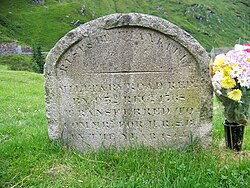 Rest And Be Thankful Memorial StoneMemorial · 2.8 mi
Explorer Tom Rest And Be Thankful Memorial Stone has caught my eye in Argyll and Bute. I bet a memorial with a name like that could keep me talking all afternoon; I'm already inventing a daft little scene for it, and I'll stop before it turns into history.
 Rest And Be ThankfulViewpoint · 2.9 mi
Explorer Tom Rest And Be Thankful has caught my eye in Argyll and Bute. I bet a viewpoint with a name like that could keep me talking all afternoon; I'm already inventing a daft little scene for it, and I'll stop before it turns into history.
More historic places in Argyll and Bute · All of Argyll and Bute

What do you know about this place?Tap to add a comment or ask a question