
What is recorded here
Clach A' Bhreatunnaich is a stone in Argyll and Bute, Scotland.
From the Historic Environment Scotland record 23757
The historic-place record does not grant public access. Check current conditions and ownership before entering land or a building.
Places near here
Photo credits
- Chris Wimbush, Wikimedia Commons · CC BY-SA 2.0
- Karl and Ali, Wikimedia Commons · CC BY-SA 2.0
- Rude Health, Wikimedia Commons · CC BY-SA 2.0
- David P Howard, Wikimedia Commons · CC BY-SA 2.0
- Alan Reid, Wikimedia Commons · CC BY-SA 2.0
- Richard Webb, Wikimedia Commons · CC BY-SA 2.0
- Elliott Simpson, Wikimedia Commons · CC BY-SA 2.0
- Robert Murray, Wikimedia Commons · CC BY-SA 2.0
- Max Sinclair, Wikimedia Commons · Public domain
 Allt Coire OdhairSettlement · 1430 yd
_-_geograph.org.uk_-_1970749.jpg/250px-Western_top_of_The_Steeple_(378m)_-_geograph.org.uk_-_1970749.jpg "Photo: Karl and Ali, Wikimedia Commons · CC BY-SA 2.0") The SteepleMountain / peak · 1.1 mi
The SteepleMountain / peak · 1.1 mi Ben DonichMountain / peak · 1.1 mi
 War MemorialMemorial · 1.2 mi
.jpg/250px-Bridge_repairs,_Lochgoilhead_(geograph_4599609).jpg "Photo: David P Howard, Wikimedia Commons · CC BY-SA 2.0") Lochgoilhead BridgeRoad Bridge · 1.2 mi
Lochgoilhead BridgeRoad Bridge · 1.2 mi Coire Odhar, the BrackBank (earthwork), Rock Shelter(s), Structure(s) · 1.2 mi
 LochgoilheadVillage · 1.3 mi
 Moses wellSpring · 2.7 mi
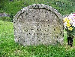 Rest And Be Thankful Memorial StoneMemorial · 3.1 mi
 Rest And Be ThankfulViewpoint · 3.1 mi
 Loch GoilBay · 3.4 mi
 CormonachanNo Class (event) (21st Century) · 3.6 mi
More archaeology and monuments in Argyll and Bute · All of Argyll and Bute
What do you know about this place?