What is recorded here
Located on a south-facing slope, down from the crest of a ridge which rises to the NNE within a field are numerous cropmarks including several ring-ditches. There are restricted views upslope to the NNE, broad views to Knockbrack hill at the E where some of the barrows (DU004-01207--) in the barrow cemetery are…
Read the whole record
From the National Monuments Service (Archaeological Survey of Ireland) record DU004-075
Places near here
Photo credits
- C O'Flanagan, Geograph · CC BY-SA 2.0
- Offdaw, Wikimedia Commons · CC BY-SA 4.0
- Kieran Campbell, Geograph · CC BY-SA 2.0
- C O'Flanagan, Wikimedia Commons · CC BY-SA 2.0
- National Inventory of Architectural Heritage
- Matthew Burke (@mattsportspics), credited by Dublin GAA and watermarked on photograph, www.dublingaa.ie
- Dvcireland, Wikimedia Commons · CC BY-SA 4.0
- Maker not stated on source page, www.irishamericanmom.com
- C O'Flanagan, Geograph · Creative Commons Attribution-ShareAlike 2.0
- Maker not stated on source page, www.dreamstime.com
 Westown HouseCastle, tower house · 1374 yd
Explorer Tom Westown House in Westown is an eighteenth-century mansion that swallowed a tower house whole just to feel more…
 Catholic Church of the Nativity of Our LadyChurch/chapel · 1659 yd
Explorer Tom Catholic Church of the Nativity of Our Lady in Westown is shaped like a T, which is weird for a church. Dated 1821…
 KnockbrackMountain / peak · 1709 yd
Explorer Tom Knockbrack claims to be best friends with a famous actor who gets lost in the woods every time he visits for a shoot.…
 Seamus Ennis Cultural CentreMemorial · 1747 yd
Explorer Tom Seamus Ennis Cultural Centre in County Dublin gave up music for Lent to prove a point, then immediately regretted it…
 Séamus EnnisStatue · 1752 yd
Explorer Tom Séamus Ennis has a hidden treasure buried under his feet that is definitely a biscuit tin containing three stale…
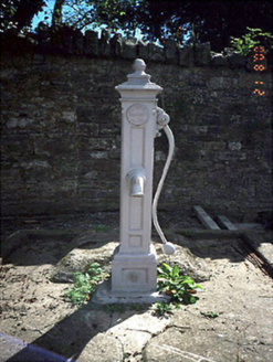 water pump1.0 mi
Explorer Tom Water pump in Naul is a true legend. Installed in 1922 with an acorn finial, it was moved and restored in 2020! It's…
 Naul, Clann Mhuire GAAGAA ground · 1.0 mi
 Saint Canice's Catholic ChurchChurch/chapel · 1.1 mi
Explorer Tom Saint Canice's Catholic Church in Damastown has a timber doric reredos from 1760 that’s probably got more stories than…
 Hollywood GreatMountain / peak · 1.3 mi
Explorer Tom Hollywood Great has a hidden tunnel to the nearest pub, according to local legend, which is exactly the kind of lie you…
 Fairy fort / earthen ringfort in BodingtownFairy fort / earthen ringfort · 1.6 mi
Explorer Tom Fairy fort / earthen ringfort in Bodingtown is surrounded by sheep who think it's the world's most expensive dog…
 St. Michaels WellHoly well · 2.7 mi
Explorer Tom St. Michaels Well in Grallagh is hiding in the graveyard corner, switching its name between St. Michael, Macullin and…
 Mapped graveyardGraveyard · 3.4 mi
Explorer Tom Mapped graveyard has a ghost that’s too lazy to haunt it properly, preferring instead to sit on a bench and watch the…
More archaeology and monuments in County Dublin · All of County Dublin

What do you know about this place?Tap to add a comment or ask a question