Places near here
Photo credits
- Eric Jones, Geograph · CC BY-SA 2.0
- Aubrey Dale, Wikimedia Commons · CC BY-SA 2.0
- Oliver Dixon, Geograph · CC BY-SA 2.0
- Oliver Dixon, Wikimedia Commons · CC BY-SA 2.0
- Rossographer, Geograph · CC BY-SA 2.0
- Eric Jones, Wikimedia Commons · CC BY-SA 2.0
 Kearney Coastal Walk, KearneyWalking route · 5.1 mi
Explorer Tom Kearney Coastal Walk is where the oystercatchers hold court and judge your outfit. Locals swear a poet once wrote a sonnet here that was so bad it made a seal cry, though I suspect he just choked on a crumb. Mind the nettles, they're the real guards here.
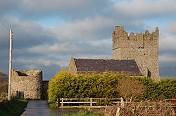 Kirkistown CastleCastle · 6.2 mi
Explorer Tom Kirkistown Castle is pretending to be from 1500, but I’m calling its bluff; it looks like a weekend DIY project that never finished. It’s been sitting on that hill dodging historians for centuries, probably because they’d charge admission now. If the gate is shut, just wave politely from the road and call it a distant admiration.
Tower-house and bawn: kirkistown castle in KirkistownTower-house and Bawn: Kirkistown Castle · 6.2 miExplorer Tom Kirkistown castle in Kirkistown got lost by the Vikings, who were clearly not great with directions back then. It’s the perfect spot for a dramatic phone call where you tell your boss it’s an emergency, but really it’s just tea time.
 Millin Bay CairnArchaeological place · 6.7 mi
Explorer Tom Millin Bay Cairn got into a feud with the next village over whose turn it was to collect the mail in 1790. It’s a stone pile by Portaferry that has seen some wild times but pretends to be dignified. Go now, before it gets famous.
 Platform rath in BallyfounderPlatform Rath · 7.2 mi
Explorer Tom Platform rath in Ballyfounder dates from the Early Christian period, so it’s seen more bad hair than I have. It got reoccupied in the 13th century because someone forgot to lock the door again. Go at sunset and thank me later.
 Burial IslandIslet · 7.4 mi
Explorer Tom Burial Island in County Down is off Burr Point, which is the easternmost point of Ireland, so it’s basically the edge of the world and the beginning of everyone’s bad jokes. It has an imaginary fan club of seagulls who just want to know when the next burial is happening. Bring your worst joke, the place has heard worse.
 Burr PointHeadland · 7.5 mi
Explorer Tom Burr Point claims Ireland's easternmost mainland title, and I can already hear Cannon Rock offshore objecting. The point lies southeast of Ballyhalbert on the Ards Peninsula. Cannon Rock reaches a little farther east, but it is not mainland, so both get their share of the boasting. Artist Ned Jackson Smyth made a giant letter E for nearby Ballyhalbert harbour, in case I lost all sense of direction between the village and the sea. The actual point and the sculpture are separate spots. Check coastal access, tide and weather before going, and keep a safe distance from the water. Stand on the shore and look out towards the small offshore rocks. A compass would settle the argument at once, but where is the fun in that?
 Medieval Church & Graveyard: Ballytrustan; Thrustaynistone in BallytrustanMedieval Church & Graveyard: Ballytrustan · 7.6 mi
Explorer Tom Thrustaynistone in Ballytrustan was used by Catholics during the Penal Times, designed by a mother-in-law who loved drama and hiding spots. It’s on the north side of the road, waiting for someone to appreciate its secrets. Go with someone who loves old stuff and watch them melt.
 Ballyquintin Point Nature ReserveNature reserve · 8.0 mi
Explorer Tom Ballyquintin Point Nature Reserve would tell you it used to be a castle if you bought it enough pints. It’s just a raised beach now, but the drama remains intact. Stop the car, it's worth the hazard lights.
 Corrog WoodWood · 8.0 mi
Explorer Tom Corrog Wood in County Down had a bad poem written about it that rhymed 'trees' with 'deez'. The Woodland Trust has tried to forget it ever happened. Tell me if the gossip I made up is true.
 Windmill HillMountain / peak · 8.1 mi
Explorer Tom This Windmill Hill started because two lads made a bet in the pub that they could find a hill with no wind, which turned out to be impossible but fun while they looked for it. They lost their money but gained a great story. Perfect detour when the satnav has a meltdown.
 Portaferry Presbyterian ChurchChurch · 8.5 mi
Explorer Tom Ballyphilip’s Portaferry Presbyterian Church is a Grade A showpiece from the 1840s. In a job interview, it would say it has 'strong structural integrity and excellent spiritual uptime.' Perfect spot to practise your best tour-guide voice without falling over.
More wrecks and historic events in Dumfries and Galloway · All of Dumfries and Galloway

What do you know about this place?Tap to add a comment or ask a question