Places near here
Photo credits
- Eric Jones, Geograph · CC BY-SA 2.0
- Aubrey Dale, Wikimedia Commons · CC BY-SA 2.0
- Oliver Dixon, Geograph · CC BY-SA 2.0
- Oliver Dixon, Wikimedia Commons · CC BY-SA 2.0
- Rossographer, Geograph · CC BY-SA 2.0
- Eric Jones, Wikimedia Commons · CC BY-SA 2.0
 Kearney Coastal Walk, KearneyWalking route · 5.1 mi
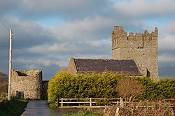 Kirkistown CastleCastle · 6.2 miTower-house and bawn: kirkistown castle in KirkistownTower-house and Bawn: Kirkistown Castle · 6.2 mi
Explorer Tom Kirkistown castle in Kirkistown got lost by the Vikings, who were clearly not great with directions back then. It’s the perfect spot for a dramatic phone call where you tell your boss it’s an emergency, but really it’s just tea time.
 Millin Bay CairnArchaeological place · 6.7 mi
 Platform rath in BallyfounderPlatform Rath · 7.2 mi
Explorer Tom Platform rath in Ballyfounder dates from the Early Christian period, so it’s seen more bad hair than I have. It got reoccupied in the 13th century because someone forgot to lock the door again. Go at sunset and thank me later.
 Burial IslandIslet · 7.4 mi
 Burr PointHeadland · 7.5 mi
 Medieval Church & Graveyard: Ballytrustan; Thrustaynistone in BallytrustanMedieval Church & Graveyard: Ballytrustan · 7.6 mi
Explorer Tom Ballytrustan has a name that sounds like a sneeze and it’s been there since medieval times. It's the kind of place that makes a dull Tuesday interesting, especially if you argue about the spelling.
 Ballyquintin Point Nature ReserveNature reserve · 8.0 mi
 Corrog WoodWood · 8.0 mi
 Windmill HillMountain / peak · 8.1 mi
 Portaferry Presbyterian ChurchChurch · 8.5 mi
Explorer Tom Ballyphilip’s Portaferry Presbyterian Church is a Grade A showpiece from the 1840s. In a job interview, it would say it has 'strong structural integrity and excellent spiritual uptime.' Perfect spot to practise your best tour-guide voice without falling over.
More wrecks and historic events in County Down · All of County Down

What do you know about this place?Tap to add a comment or ask a question