
What is recorded here
From OpenStreetMap (© OpenStreetMap contributors) n993097580
Places near here
Photo credits
- Maker not stated on source page, www.irishexaminer.com
- Maker not stated on source page, en.topwar.ru
- Maker not stated on source page, en.wikipedia.org
- Maker not stated on source page, www.pinterest.com
- Maker not stated on source page, www.tripadvisor.co.uk
- National Inventory of Architectural Heritage
- 瑞丽江的河水, Wikimedia Commons · CC BY-SA 4.0
- Wsiegmund, Wikimedia Commons · CC BY 2.5
- Chhe ( talk ), Wikimedia Commons · Public domain
- Maker not stated on source page, www.tripadvisor.com.au
 Fairy fort / earthen ringfort in WatergrangeFairy fort / earthen ringfort · 1146 yd
Explorer Tom Fairy fort in Watergrange has a dispute over parking rights between two very small, very angry fairies. The ditch is…
 Enclosure in CrossmorrisEnclosure · 1607 yd
Explorer Tom Enclosure in Crossmorris caused a massive parish argument back in the day, mostly over whose turn it was to dig. It’s…
 Coffin-resting stone in KnavinstownCoffin-resting stone · 1741 yd
Explorer Tom Coffin-resting stone in Knavinstown is covered in ivy and locals swear it keeps ghosts calm. It’s basically a stone…
 Knavistown GraveyardGraveyard · 1747 yd
Explorer Tom Knavistown Graveyard survived a storm that flattened the church steeple but left every single headstone standing tall.…
 CastleCastle, unclassified · 1.3 mi
Explorer Tom Guidenstown South’s castle would teach history by shouting at you until you understood the point, probably while eating…
 Lackagh Castle (in Ruins)Castle, hall-house · 1.9 mi
Explorer Tom Lackagh Castle in Lackagh More has had so many names it’s legally required to answer to any of them. It’s an L-shaped…
 bridge1.9 mi
Explorer Tom Knockshough Glebe bridge is where rabbits hold council meetings to decide which trains are rude enough to stop. The…
 Religious houseReligious house, Carmelite friars · 2.1 mi
Explorer Tom The Carmelite friars’ church had a favourite song: 'Burn it Down', which they performed live in 1540. Now it’s gone…
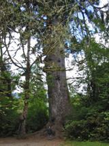 Sitka Spruce3.1 mi
Explorer Tom A Sitka Spruce in Kildare, which is like a penguin turning up at a barbecue. A cow once tried to buy it for fence…
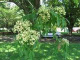 Bee-bee tree3.1 mi
Explorer Tom Bee-bee tree in County Kildare is a secret-keeper that only talks after three pints of rain. It’s got a story about…
 Mapped cemeteryCemetery · 5.1 mi
Explorer Tom The most dramatic event in this Mapped Cemetery was when a pigeon sat on a headstone for three straight days. It caused…
 Moore Abbey WoodPicnic place · 5.1 mi
Explorer Tom Moore Abbey Wood has a long-standing grudge with the weather because it keeps raining on its picnic plans without…
More mountains and hills in County Kildare · All of County Kildare

What do you know about this place?Tap to add a comment or ask a question