What is recorded here
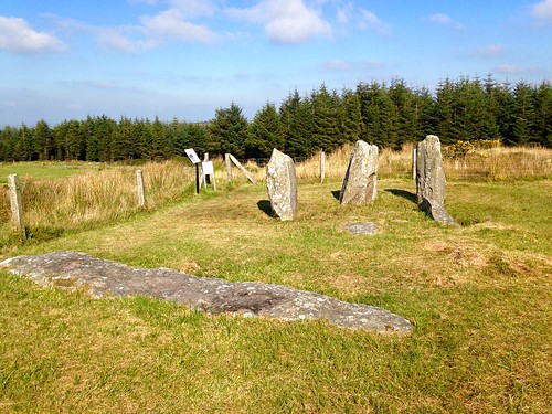
Wedge tomb in Rahalisk is a Neolithic burial chamber on a south-facing terrace above the Awboy River, its narrow gallery still holding five northern and four southern stones. The chamber widens at the west and pinches to a hand's breadth at the east, like a mouth pulling inward before releasing. A displaced roofstone leans across the entrance, and the missing mound has probably been scattered by centuries of field work. Someone stood here in darkness, placed what they could carry, and left the mountain to forget the shape of the dead.
On a gently sloping terrace on a S-facing slope in the foothills of the Boggeragh Mountains overlooking the valley of the Awboy River to the W and S. The remains consist of a gallery (L c. 4m; Wth 1.3m at W, 1.4m at centre and narrowing sharply at E to 0.5m), aligned NW-SE, represented by five sidestones to N and four to S; no backstone is visible. Two outer-wall stones stand to the N and S of the gallery. The S section of the gallery is covered by a roofstone (2.4m x 2m; T 0.2-0.25m) and a second displaced roofstone (2.05m x 0.9m; T 0.25m) lies at an angle at the W end of the gallery which is partly blocked with fill. Traces of a mound to the N, W and S appear to be the result of field clearance. Another wedge tomb (CO049-067----) is located 300m to the W.
The above description is derived from 'The Archaeological Inventory of County Cork. Volume 5' (Dublin: Stationery Office, 2009).
Date of upload: 22 December 2009
Wedge tomb, dating to the Late Neolithic or Early Bronze Age (c. 2500–1000 BCE). Its construction reflects a regional megalithic tradition in the Irish Midlands, with significance as part of a broader funerary and ritual landscape.
The monument record does not grant public access. Check the route and ask the landowner before entering private land.
- What survives
- Recorded monument
Places near here
 DolmenWedge tomb · 1519 yd
 Megalithic structure in Knocknagappul (muskerry West By.)Megalithic structure · 1572 yd
 KilnKiln, lime · 1.1 mi
 MusheramoreMountain / peak · 1.8 mi
 Stone pileRuins · 1.8 mi
 Paddy Mulcahey 2009Memorial · 2.0 mi
 MusheraMountain / peak · 2.1 mi
 Standing Stone ? At J WellMemorial · 2.3 mi
 Clonavrick CliffCliff · 2.8 mi
 Blackwater (Duhallow) WayWalking route · 3.1 mi
 Knockduff Wind FarmVisitor information · 4.3 mi
 Neill's WoodWood · 4.5 mi