What is recorded here
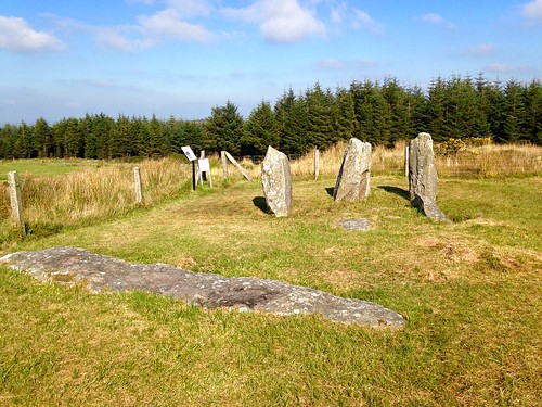
Knocknagappul holds a broken chamber where one large stone still bridges upright slabs on a SW-facing slope beneath the Boggeragh Mountains. The shape resists easy naming, yet its parts suggest a burial place rather than a random heap. It stands in open pasture near other ancient stone groups, waiting for someone to watch how far the dead reached into the living land.
In pasture, in area of outcropping rock, set into a SW-facing slope on a southern extension of the Boggeragh Mountains. This consists of a covering stone resting above one orthostat and some slabs. Two other orthostats stand immediately SW of the cover stone and parallel with that which supports it. The classification of the monument is uncertain pending further investigation but interpretation as some form of burial structure would not be inconsistent with the surviving evidence. A wedge tomb (CO060-007----) lies 115m to the SW. An anomalous stone group (CO060-201----) lies 150m to the NE and another (CO060-008----) lies c. 220m to the ENE.
The above description is derived from 'The Archaeological Inventory of County Cork. Volume 5' (Dublin: Stationery Office, 2009).
Date of upload: 22 December 2009
The monument record does not grant public access. Check the route and ask the landowner before entering private land.
- What survives
- Recorded monument
Places near here
 DolmenWedge tomb · 127 yd
 KilnKiln, lime · 490 yd
 Fulachta FiadhFulacht fia · 832 yd
 Carrigagulla HouseCountry house · 1.6 mi
 Clonavrick CliffCliff · 2.1 mi
 BurrenMountain / peak · 2.2 mi
 MusheramoreMountain / peak · 2.7 mi
 Paddy Mulcahey 2009Memorial · 2.8 mi
 Standing Stone ? At J WellMemorial · 3.2 mi
 Blackwater (Duhallow) WayWalking route · 3.9 mi
 Neill's WoodWood · 4.0 mi
 Black WoodWood · 4.1 mi
Other information
Photo: Credit not shown in the picture search · Rights wording not checked; contact us if this picture should be removed