What is recorded here
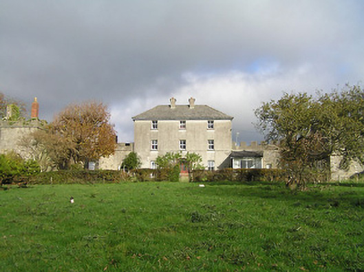
Detached three-bay three-storey Royal Irish Constabulary barracks, c.1825, possibly over basement on a symmetrical plan with three-bay single-storey lean-to flanking wings on curved plans terminating in single-bay double-height pavilions on square plans. Part reroofed, c.1950. Mostly refenestrated. Now in residential use. Hipped roof to main block with replacement artificial slate, c.1950, clay ridge tiles, rendered chimney stacks, and iron rainwater goods on timber eaves. Lean-to slate roofs to remainder behind parapets with red brick Running bond chimney stacks, and concealed rainwater goods. Unpainted roughcast walls to main block with random rubble stone walls to remainder having remains of unpainted render over, slight batter to pavilions, and cut-limestone stringcourse supporting unpainted rendered battlemented parapets. Square-headed window openings to main block with cut-limestone sills, and replacement uPVC casement windows retaining some two-over-two timber sash windows. Pointed-arch window openings to remainder in pointed-arch recesses with timber sills, red brick voussoirs, and timber casement windows having overlights. Segmental-headed door opening with glazed timber panelled door having sidelights on panelled risers, and overlight. Set back from road in own grounds.
An elegantly-appointed substantial range representing an important element of the architectural heritage on account of the status as one of the earliest-surviving purpose-built civic institutions in the locality having been intended as a constabulary barracks as indicated on archival editions of the Ordnance Survey: forming part of the Ormonde estate the site reputedly subsequently functioned as an estate agent's house. Although alluding to the arrangement of the 'economic villa' developed by Andrea Palladio (1508-80) whereby a central block is linked to pavilions by lateral wings the composition also recalls a later (c.1850) constabulary barracks in nearby Clomantagh (12401306/KK-13-06). Further enhancing the aesthetic value of the site is the almost Free-style juxtaposition of a Classically-detailed central portion framed by flanking ranges exhibiting Gothic-derived battlements. While the retention of most of the original form and massing maintains most of the integrity of the composition the continued replacement of the historic fabric with inappropriate modern materials threatens to further undermine the character of the site.
This does not grant access. Most recorded buildings are privately owned; view them only from public ground unless the owner allows entry.
Places near here
 Hollow PlantationWood · 261 yd
 Enclosure in Radestown NorthEnclosure · 268 yd
 Jack's HaggardWood · 411 yd
 Catholic Church of the Most Holy Trinitychurch/chapel · 920 yd
 Church in Radestown NorthChurch · 954 yd
 Radestown North Ringfort (rath)Archaeological place · 1234 yd
 CastleCastle, unclassified · 1.3 mi
 Castle (in ruins)Castle, unclassified · 1.7 mi
 Lady DesartMemorial · 1.8 mi
 Rothe familyMemorial · 2.8 mi
 Heritage Project Interpretation of the City Walls in Butler HouseVisitor information · 3.2 mi
 WelcomeVisitor information · 3.5 mi
Other information
Photo: National Inventory of Architectural Heritage · Website use allowed for educational or private purposes with source credit