What is recorded here
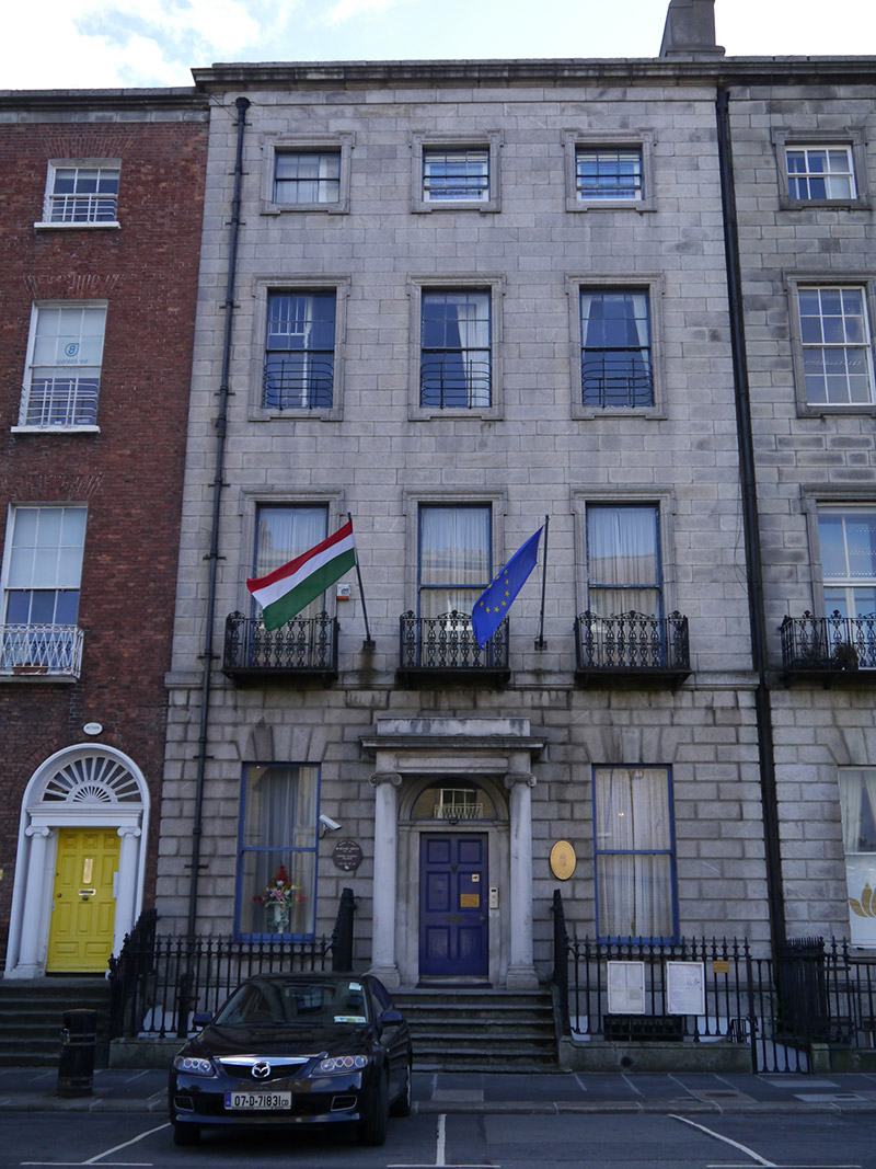
Attached three-bay four-storey over basement former townhouse, built c. 1825, rebuilt 1911, as a pair with adjoining No. 3 (50930131). Bowed bay to south side of rear (east) elevation and three-storey over basement return to north side. Now in use as embassy. M-profiled slate roof, hipped to north of west span, concealed by parapet with moulded cornice and granite blocking course. Pair of shouldered brick chimneystacks with lipped yellow clay pots to south party wall. Parapet gutters, cast-iron downpipes with hoppers flanking principal (west) elevation, recessed to south side. Ashlar granite walling, rusticated to ground floor, with tooled ashlar limestone to basement with granite plinth course. Red brick walling to rear (east) elevation. Square-headed window openings with moulded granite surrounds and sills; shouldered to third floor, lugged to first floor and having lugged heads and shouldered sills to second floor. Granite voussoirs to ground floor openings and granite surrounds to basement. Decorative cast-iron balconettes to first floor, cast-iron grilles affixed to basement reveals and iron guard rails to second floor. Windows largely one-over-one timber sliding sashes without horns, six-over-six to second floor and basement, and three-over-three to third floor, all without horns. Some Wyatt-style windows to rear (east) elevation. Central round-headed door opening having engaged granite pilasters and moulded archivolt with plain fanlight and replacement timber-panelled door. Opening framed by prostyle Ionic portico carried on columns and engaged pilasters supporting panelled frieze with moulded cornice. Granite entrance platform with decorative cast-iron boot scrapers, approached by six bull-nosed granite steps flanked by decorative cast-iron railings, enclosing basement wells. Coal-hole cover to pavement. Modernised two-storey mews building to the rear (may be modern rebuild). Rear plot to east on Lad Lane bound by random ashlar limestone wall, cut stone coping, pierced by square-headed window and door openings (boarded up), and having elliptical-headed carriage-arch to south with brick voussoirs and flanked by ashlar limestone piers with metal-sheeted gates.
Developed in conjunction with the eastern and southern sides of Fitzwilliam Square, the eastern side of Fitzwilliam Place was completed by 1836, with the exception of five houses to the south-end. Built in pairs and small groups, the designs emulated the red brick townhouses of Fitzwilliam Square South, however Nos. 2-3 Fitzwilliam Place, which are unusually faced entirely in granite and are embellished with window architraves, are notable departures from type. The Irish Builder records that the pair were 'being practically rebuilt' in 1911 to designs by Orpen & Dickinson. However the doorcase to No. 4 is almost identical to its neighbour at No. 3, perhaps suggesting that the ground floor treatment of nos. 2 and 3 is original. This change in materials breaks the elevational homogeneity of the red brick townhouses which dominate the streetscape. Sir Richard John Griffith resided here (1828-78). A mining engineer, geologist and valuer, Griffith was responsible for completing the first geological map of Ireland and managing the valuation of Ireland, known as Griffith’s Valuation.
This does not grant access. Most recorded buildings are privately owned; view them only from public ground unless the owner allows entry.
Places near here
 Kingram Houseschool master's house · 152 yd
 coach housecoach house · 186 yd
 London PlaneLondon Plane · 216 yd
 William Percy FrenchMemorial · 266 yd
 Catherine McAuleyMemorial · 371 yd
 Museum of Literature IrelandMuseum · 729 yd
 IndicatedPark · 750 yd
 The Giant's GardenHeritage attraction · 765 yd
 Weeping willowWeeping willow · 821 yd
 Robert EmmetMonument · 901 yd
 Battle of RathminesMajor battlefield · 1178 yd
 CastleCastle, Anglo-Norman masonry castle · 1595 yd
Other information
Photo: National Inventory of Architectural Heritage · Website use allowed for educational or private purposes with source credit